IMAGES TAKEN NEAR TO
Greggs Quay, BELFAST, BT5 4GQ
Introduction
This page details the photographs taken nearby to Greggs Quay, BT5 4GQ by members of the Geograph project.
The Geograph project started in 2005 with the aim of publishing, organising and preserving representative images for every square kilometre of Great Britain, Ireland and the Isle of Man.

There are currently over 7.5m images from over14,400 individuals and you can help contribute to the project by visiting https://www.geograph.org.uk
Image Map
Images are licensed for reuse under creativecommons.org/licenses/by-sa/2.0
Notes
- Clicking on the map will re-center to the selected point.
- The higher the marker number, the further away the image location is from the centre of the postcode.
Image Listing (2646 Images Found)
Images are licensed for reuse under creativecommons.org/licenses/by-sa/2.0
Image
Details
Distance
1
Dredging the River Lagan, Belfast - 2010/11 (103)
Image: © Albert Bridge
Taken: 11 Jan 2011
0.00 miles
2
Dredging the River Lagan, Belfast - 2010/11 (11)
After discharge of the spoil Image the barge “Beachley” heads upstream, past Gregg’s Quay, towards Stranmillis.
Image: © Albert Bridge
Taken: 5 Oct 2010
0.01 miles
3
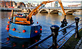
Dredging the River Lagan, Belfast - 2010/11 (98)
The crane barge working alone, very close to the Laganside walkway, at Gregg’s Quay.
Image: © Albert Bridge
Taken: 11 Jan 2011
0.01 miles
4
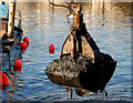
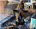
Dredging the River Lagan, Belfast - 2010/11 (102)
The crane barge lifts another bucket of malodorous silt from the Lagan, off Gregg’s Quay.
Image: © Albert Bridge
Taken: 11 Jan 2011
0.01 miles
5
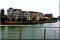
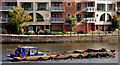
Belfast City Centre - Residential Housing along East Bank of River Lagan
Location is just south of Queens Bridge. View is to southeast from west end of Queens Bridge.
Image: © Joseph Mischyshyn
Taken: 23 Sep 2013
0.01 miles
6
Belfast City Centre - Residential Housing along East Bank of River Lagan
Location is along east bank of the River Lagan, just south of Queens Bridge. View is to northeast from west bank of the River Lagan just south of the Barge Confiance.
Image: © Joseph Mischyshyn
Taken: 23 Sep 2013
0.01 miles
7
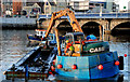
Dredging the River Lagan, Belfast - 2010/11 (101)
The crane barge loading the “Cranagh Star’s” dumb barge Image off Gregg’s Quay.
Image: © Albert Bridge
Taken: 11 Jan 2011
0.01 miles
8
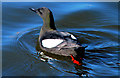
Black guillemot, River Lagan, Belfast
See Image Black guillemots are now common around Belfast harbour and the Lagan. Despite all the rebuilding work there still seems to be enough holes left for their nests. This one was in the Lagan, off Gregg’s Quay, close to the Queen’s Bridge. Continue to Image
Image: © Albert Bridge
Taken: 18 Mar 2011
0.01 miles
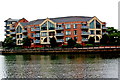
9
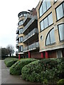
Gregg's Quay apartments and Laganside walkway
On the east bank of the Lagan, in the centre of Belfast.
Image: © Christine Johnstone
Taken: 20 Mar 2023
0.01 miles
10
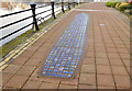
"Starboard 2001" sculpture, Belfast (1)
A sculpture, at Gregg’s Quay, close to the Queen’s Bridge dating from 2001. The sculptor was Rachel Joynt. The official description is as follows: “This (8.5m long) ship plan is made of translucent blue cobbles surrounded by a cast iron frame. The cobbles have starfish embedded within to suggest sea and sky and are lit from underneath with fibre optic lighting. Inspired by the graving docks and the traffic of cargo ships that once docked alongside Gregg’s Quay, but primarily it can be seen as a window into the sea or a mirror of the sky”. Image shows the name of the casting foundry.
Image: © Albert Bridge
Taken: 6 Feb 2012
0.01 miles