IMAGES TAKEN NEAR TO
Templemore Avenue, BELFAST, BT5 4FS
Introduction
This page details the photographs taken nearby to Templemore Avenue, BT5 4FS by members of the Geograph project.
The Geograph project started in 2005 with the aim of publishing, organising and preserving representative images for every square kilometre of Great Britain, Ireland and the Isle of Man.

There are currently over 7.5m images from over14,400 individuals and you can help contribute to the project by visiting https://www.geograph.org.uk
Image Map
Images are licensed for reuse under creativecommons.org/licenses/by-sa/2.0
Notes
- Clicking on the map will re-center to the selected point.
- The higher the marker number, the further away the image location is from the centre of the postcode.
Image Listing (218 Images Found)
Images are licensed for reuse under creativecommons.org/licenses/by-sa/2.0
Image
Details
Distance
1
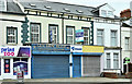
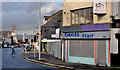
Nos 81&83 Castlereagh Road, Belfast (December 2017)
Shops, on the ground floor, with offices to let upstairs. Described by the agents as “The offices have been finished to a high standard to include plastered and painted walls, wooden laminate flooring and fluorescent strip lighting.” I have no connection with the property or the letting.
Image: © Albert Bridge
Taken: 7 Dec 2017
0.02 miles
2
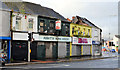
"Spence's" chippy, Belfast
The locally-famous east Belfast chippy, at the corner of Calvin Street and the Beersbridge Road (foreground) is now offered for sale.
Image: © Albert Bridge
Taken: 22 Dec 2011
0.02 miles
3
No 62 Beersbridge Road, Belfast - May 2018(1)
The vacant no 62 Beersbridge Road. Calvin Street is on the right.
Image: © Albert Bridge
Taken: 30 May 2018
0.03 miles
4
No 62 Beersbridge Road, Belfast - May 2018(2)
The vacant no 62 Beersbridge Road from the south. Part of Calvin Street can be seen at lower right.
Image: © Albert Bridge
Taken: 30 May 2018
0.03 miles
5
Regeneration site, east Belfast (2)
A regeneration site, between Kenbaan Street and Clandeboye Street (right background).
Image: © Albert Bridge
Taken: 17 Oct 2012
0.04 miles
6
No 70 Beersbridge Road, Belfast
See Image (October 2012). The vacant shop now has a “sold” sign. It seems to have formed part of a large auction sale conducted during November 2013.
Image: © Albert Bridge
Taken: 7 Dec 2013
0.05 miles
7
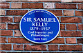
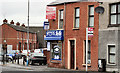
Sir Samuel Kelly plaque, Belfast
A plaque, at 94 Castlereagh Street, commemorating Sir Samuel Kelly http://www.ulsterhistory.co.uk/kelly.htm.
Image: © Albert Bridge
Taken: 28 Mar 2010
0.05 miles
8
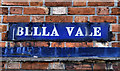
"Bella Vale" sign, Belfast
Enamel sign on 94 Castlereagh Street, the birthplace of Sir Samuel Kelly Image – now a dentist’s.
Image: © Albert Bridge
Taken: 28 Mar 2010
0.05 miles
9
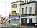
Former barber's shop, Belfast
Former barber’s shop, on the Beersbridge Road side of John Long’s corner, between here Image and here Image (right), offered “for sale”.
Continue to Image (December 2013).
Image: © Albert Bridge
Taken: 17 Oct 2012
0.06 miles
10
Nos 1-21 Castlereagh Road, Belfast (1)
The row seen from close to the end of the Beersbridge Road.
Image: © Albert Bridge
Taken: 17 Oct 2012
0.06 miles