IMAGES TAKEN NEAR TO
Scrabo Street, BELFAST, BT5 4BD
Introduction
This page details the photographs taken nearby to Scrabo Street, BT5 4BD by members of the Geograph project.
The Geograph project started in 2005 with the aim of publishing, organising and preserving representative images for every square kilometre of Great Britain, Ireland and the Isle of Man.

There are currently over 7.5m images from over14,400 individuals and you can help contribute to the project by visiting https://www.geograph.org.uk
Image Map
Images are licensed for reuse under creativecommons.org/licenses/by-sa/2.0
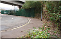
Notes
- Clicking on the map will re-center to the selected point.
- The higher the marker number, the further away the image location is from the centre of the postcode.
Image Listing (2073 Images Found)
Images are licensed for reuse under creativecommons.org/licenses/by-sa/2.0
Image
Details
Distance
1
Scrabo Street, Belfast
Scrabo Street ran along the southern side of Queen’s Quay station Image It is now a name only running under the cross-harbour road and railway and serving as access to the Quay Gate apartments Image and Quay Gate House Image The view is towards Queen’s Quay. The Google map is a bit inaccurate.
Image: © Albert Bridge
Taken: 6 Oct 2009
0.01 miles
2
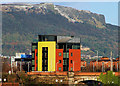
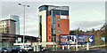
Quay Gate House, Belfast (2)
The distinctive colours of Quay Gate House Image, in Scrabo Street, seen from the Albert Bridge. The equally distinctive profile of Napoleon’s Nose Image, on the Cave Hill, is at top right.
Image: © Albert Bridge
Taken: 27 Dec 2009
0.02 miles
3
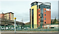
The Residence at Quay Gate site, Belfast (November 2018)
The view from Middlepath Street. The developer’s website records “Residence of Quay Gate Vinder acquired this strategic city centre site with a joint venture partner in Oct 2017. We are currently compiling a major planning application for a build to rent scheme” (November 2018).
Image: © Albert Bridge
Taken: 25 Nov 2018
0.02 miles
4
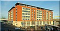
Quay Gate, Belfast
Apartments between Station Street, Scrabo Street and Middlepath Street. There is also a nearby office building known as “Quay Gate House” Image Image shows the site in 1991.
Image: © Albert Bridge
Taken: 28 Jan 2009
0.02 miles
5
Queen's Quay station - general view
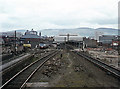
Taken from the steps of the UTA built signal cabin, the platforms at left were used for carriage washing, while the former carriage sheds can be seen above the yellow "Graham" tanker. Platforms 1 & 2 are occupied by MED sets, while the desolation around former Platforms 4 & 5 is evident. The spire of Belfast's landmark Albert Clock can be seen just above the MED in Platform 1. All locations are approximate as this site is now under the M3 motorway/cross-harbour link.
Image: © The Carlisle Kid
Taken: 10 Apr 1976
0.02 miles
6
Quay Gate Court, Belfast - November 2017(1)
The view from Middlepath Street. Quay Gate House Image is on the left.
Image: © Albert Bridge
Taken: 26 Nov 2017
0.02 miles
7
Quay Gate Court, Belfast - November 2017(2)
The view from the corner of Dalton Street. Quay Gate House Image is in the middle.
Image: © Albert Bridge
Taken: 26 Nov 2017
0.02 miles
8
Railway at Bridge End, Belfast
See Image This is the section of the line just after crossing Bridge End. It is mostly single track having been built that way as an economy measure. It carries around 90 passenger trains daily in addition to numerous empty stock workings between Central and the workshops at York Road and Fortwilliam. The view is towards Yorkgate.
Image: © Albert Bridge
Taken: 25 Jun 2007
0.02 miles
9
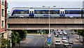
Elevated train, Belfast
The 16.00 Belfast Gt Victoria Street – Londonderry crossing Middlepath Street.
Image: © Albert Bridge
Taken: 1 Sep 2010
0.03 miles
10
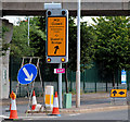
Diversion signs, Belfast (2)
Image: © Albert Bridge
Taken: 8 Aug 2010
0.03 miles