IMAGES TAKEN NEAR TO
Torr Road, BALLYCASTLE, BT54 6RH
Introduction
This page details the photographs taken nearby to Torr Road, BT54 6RH by members of the Geograph project.
The Geograph project started in 2005 with the aim of publishing, organising and preserving representative images for every square kilometre of Great Britain, Ireland and the Isle of Man.

There are currently over 7.5m images from over14,400 individuals and you can help contribute to the project by visiting https://www.geograph.org.uk
Image Map
Images are licensed for reuse under creativecommons.org/licenses/by-sa/2.0
Notes
- Clicking on the map will re-center to the selected point.
- The higher the marker number, the further away the image location is from the centre of the postcode.
Image Listing (10 Images Found)
Images are licensed for reuse under creativecommons.org/licenses/by-sa/2.0
Image
Details
Distance
1
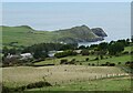
Torr with Torr Head in the background
Viewed from Torr Road.
Image: © Russel Wills
Taken: 16 Sep 2023
0.02 miles
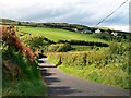
2
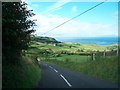
The Torr Road descending northwards towards the Altmore Valley
Image: © Eric Jones
Taken: 13 Aug 2011
0.04 miles
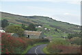
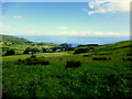
4

Green Hill
The farm is on the northern slopes of Green Hill, looking towards Greenanmore in the distance.
Image: © Anne Burgess
Taken: 6 Jun 2007
0.07 miles

6
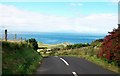
The Torr Road south of Torr Head
Torr Head is the rocky outcrop in the middle distance.
Image: © Eric Jones
Taken: 13 Aug 2011
0.10 miles
8
Torr, County Antrim
Looking north-east from Torr Road
Image: © Kenneth Allen
Taken: 5 Jul 2014
0.19 miles
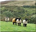
9
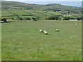
Torr, sheep grazing
On the slopes of Green Hill.
Image: © Mike Faherty
Taken: 29 Jun 2018
0.20 miles
10
Torr Road crossing the valley of the Altmore Burn
The settlement on the ridge above is Farranmacallan.
Image: © Eric Jones
Taken: 13 Aug 2011
0.23 miles