IMAGES TAKEN NEAR TO
Drumlee Road, BALLYMONEY, BT53 7LE
Introduction
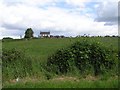
This page details the photographs taken nearby to Drumlee Road, BT53 7LE by members of the Geograph project.
The Geograph project started in 2005 with the aim of publishing, organising and preserving representative images for every square kilometre of Great Britain, Ireland and the Isle of Man.

There are currently over 7.5m images from over14,400 individuals and you can help contribute to the project by visiting https://www.geograph.org.uk
Image Map
Images are licensed for reuse under creativecommons.org/licenses/by-sa/2.0
Notes
- Clicking on the map will re-center to the selected point.
- The higher the marker number, the further away the image location is from the centre of the postcode.
Image Listing (5 Images Found)
Images are licensed for reuse under creativecommons.org/licenses/by-sa/2.0
Image
Details
Distance
3
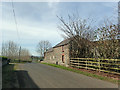
Drumlee Road
Substantial roadside farm building looking west.
Image: © Robert Ashby
Taken: 26 Mar 2017
0.19 miles
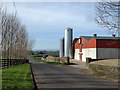
5
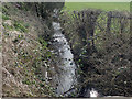
Drumlee Road
Slackwater Burn near Finvoy. One of many little watercourses which drain this area. They all end up in the nearby Lower Bann and eventually the Atlantic Ocean. Looking NNW.
Image: © Robert Ashby
Taken: 26 Mar 2017
0.24 miles