IMAGES TAKEN NEAR TO
Boyland Road, BALLYMONEY, BT53 7HF
Introduction
This page details the photographs taken nearby to Boyland Road, BT53 7HF by members of the Geograph project.
The Geograph project started in 2005 with the aim of publishing, organising and preserving representative images for every square kilometre of Great Britain, Ireland and the Isle of Man.

There are currently over 7.5m images from over14,400 individuals and you can help contribute to the project by visiting https://www.geograph.org.uk
Image Map
Images are licensed for reuse under creativecommons.org/licenses/by-sa/2.0
Notes
- Clicking on the map will re-center to the selected point.
- The higher the marker number, the further away the image location is from the centre of the postcode.
Image Listing (4 Images Found)
Images are licensed for reuse under creativecommons.org/licenses/by-sa/2.0
Image
Details
Distance
1
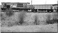
Ballast train, Ballyboyland (1985)
102 “Falcon” discharging ballast, from three hoppers, close to Ballyboyland level crossing.
Image: © Albert Bridge
Taken: 3 Feb 1985
0.08 miles
2

Ballyboyland signal cabin near Ballymoney
The UTA built the cabin and passing loop in 1958 to divide the steep section between Killagan and Ballymoney. It closed in 1969 and was subsequently demolished. The brown object on its right is the remains of the tablet catcher.
Image: © Albert Bridge
Taken: 2 Jul 1983
0.09 miles
3
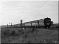
Train at Ballyboyland crossing
One of NIR's 70-class DMUs heads a heavy return Portrush - Belfast "Sunday School" excursion towards Ballyboyland level crossing at MP50.3 east of Ballymoney.
Image: © The Carlisle Kid
Taken: 7 Jun 1975
0.10 miles
4
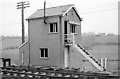
Ballyboyland signal cabin - 1975
Situated at MP50.75 on the Belfast (York Road) - Londonderry/Derry main line, Ballyboyland cabin was a UTA structure dating from 1958. It closed in 1969 and was later demolished. See also: Image] .
Image: © The Carlisle Kid
Taken: 1 Jan 1975
0.15 miles