IMAGES TAKEN NEAR TO
Rowan Road, BALLYMONEY, BT53 7AQ
Introduction
This page details the photographs taken nearby to Rowan Road, BT53 7AQ by members of the Geograph project.
The Geograph project started in 2005 with the aim of publishing, organising and preserving representative images for every square kilometre of Great Britain, Ireland and the Isle of Man.

There are currently over 7.5m images from over14,400 individuals and you can help contribute to the project by visiting https://www.geograph.org.uk
Image Map
Images are licensed for reuse under creativecommons.org/licenses/by-sa/2.0
Notes
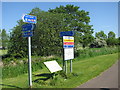
- Clicking on the map will re-center to the selected point.
- The higher the marker number, the further away the image location is from the centre of the postcode.
Image Listing (21 Images Found)
Images are licensed for reuse under creativecommons.org/licenses/by-sa/2.0
Image
Details
Distance
1
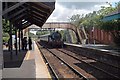
Ballymoney Station
GNRI 85 approaching Ballymoney Station.
The footbridge to the front of the engine, is out of use to passengers due to its unsafe condition. A temporary footbridge has been provided to allow passengers access to the loop platform.
Image: © Wilson Adams
Taken: 20 Jun 2004
0.05 miles
2
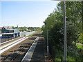
Railway line Ballymoney
Looking North-east towards the B62 road bridge. Taken from the pedestrian walkway.
Image: © Willie Duffin
Taken: 9 Jun 2013
0.12 miles
3
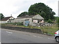
Disused poultry processing plant
This is all that remains of Duffins poultry store, my Father's business until his death in the early 70s. The white building at the left is a recently constructed Elim Church and has no connection with the factory. The partially demolished building on the right was the cold store which had the refrigeration unit in a small lean-to at this end. The main building was used for storage and packaging of poultry for export to England and to retail outlets throughout N.Ireland. The flat roofed building at the far end was the "killing and plucking area" and also where the live chickens etc. were stored until time of execution.
Image: © Willie Duffin
Taken: 13 Aug 2007
0.14 miles
4
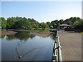
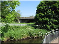
Riverside Park Ballymoney
Leisure facilities along the Ballymoney burn.
Image: © Willie Duffin
Taken: 9 Jun 2013
0.15 miles
5
Information signs Ballymoney Riverside Park
A number of signs along the riverside path. I was amused to see the "Do not enter the water" instruction, this was the river where I learned to swim.
Image: © Willie Duffin
Taken: 9 Jun 2013
0.15 miles
6
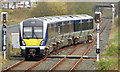
Departure from Ballymoney station - April 2014(1)
The 11.05 Portrush – Belfast Gt Victoria Street (4009) (right in Image) departing Ballymoney for Belfast. The loop, now with colour light signals, is controlled from Coleraine Image It was once signalled with somersault semaphores operated by the signalman in Ballymoney cabin Image What looks like a barrow path is a former accommodation crossing made redundant by the new footbridge.
Image: © Albert Bridge
Taken: 4 Apr 2014
0.17 miles
7
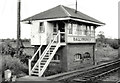
Ballymoney signal cabin
Ballymoney signal cabin, at the Belfast end of the up platform, controlled a passing loop and somersault signals. Now replaced by remotely-controlled colour lights.
Image: © Albert Bridge
Taken: 9 Jun 1979
0.17 miles
8
Bridge over railway line in Ballymoney
The B62 runs over the rail line and the Ballymoney burn at this point.
Image: © Willie Duffin
Taken: 9 Jun 2013
0.18 miles
9
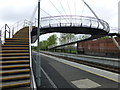
Elevated footpath, Ballymoney Railway Station
Looking ENE
Image: © Kenneth Allen
Taken: 1 Jun 2013
0.18 miles
10
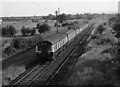
MPD train leaving Ballymoney
A lengthy MPD set pulls away from Ballymoney station with a return Portrush - Belfast "Sunday School" excursion. The MPDs were built by the Ulster Transport Authority between 1957 and 1959, mostly converted from locomotive hauled coaching stock.
Image: © The Carlisle Kid
Taken: 21 Jun 1975
0.19 miles