IMAGES TAKEN NEAR TO
Mountview Close, BALLYMONEY, BT53 6TG
Introduction
This page details the photographs taken nearby to Mountview Close, BT53 6TG by members of the Geograph project.
The Geograph project started in 2005 with the aim of publishing, organising and preserving representative images for every square kilometre of Great Britain, Ireland and the Isle of Man.

There are currently over 7.5m images from over14,400 individuals and you can help contribute to the project by visiting https://www.geograph.org.uk
Image Map
Images are licensed for reuse under creativecommons.org/licenses/by-sa/2.0
Notes
- Clicking on the map will re-center to the selected point.
- The higher the marker number, the further away the image location is from the centre of the postcode.
Image Listing (8 Images Found)
Images are licensed for reuse under creativecommons.org/licenses/by-sa/2.0
Image
Details
Distance
1
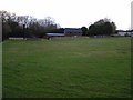
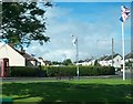
Ballybogy, County Antrim
Looking southwards
Image: © Kenneth Allen
Taken: 1 Feb 2008
0.10 miles
2
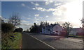
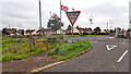
The B62
Looking SSE towards Ballymoney.
Image: © Robert Ashby
Taken: 29 Oct 2017
0.10 miles
3
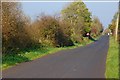
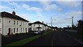
The Heagles Road near Ballybogey
The Heagles Road runs from Ballybogey village, through boggy land, towards the Seacon Road and Ballymoney. The view is towards Ballybogey.
Image: © Albert Bridge
Taken: 25 Oct 2007
0.12 miles
4
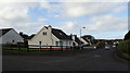
Ballybogy, County Antrim
The road ahead is for Portrush and Bushmills, to the right it leads to Derrykeighan and Ballycastle.
Image: © Kenneth Allen
Taken: 16 Feb 2007
0.14 miles
5
Ballybogy Village
The village, which is part of the Ballymoney Borough, has a population of under 300.
Image: © Eric Jones
Taken: 9 Aug 2011
0.15 miles
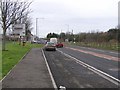
6
Ballybogey Road/Benvardin Road junction
Image: © Mick Garratt
Taken: 2 Aug 2016
0.16 miles
7
Ballindreen Road
Attractive modern housing in Ballybogey.
Image: © Robert Ashby
Taken: 29 Oct 2017
0.18 miles
8
Ballindreen Road
Housing development at Meadowbrook in Ballybogey.Meadowbrook
Image: © Robert Ashby
Taken: 29 Oct 2017
0.18 miles