IMAGES TAKEN NEAR TO
Rosemary Place, COLERAINE, BT52 2AU
Introduction
This page details the photographs taken nearby to Rosemary Place, BT52 2AU by members of the Geograph project.
The Geograph project started in 2005 with the aim of publishing, organising and preserving representative images for every square kilometre of Great Britain, Ireland and the Isle of Man.

There are currently over 7.5m images from over14,400 individuals and you can help contribute to the project by visiting https://www.geograph.org.uk
Image Map
Images are licensed for reuse under creativecommons.org/licenses/by-sa/2.0
Notes
- Clicking on the map will re-center to the selected point.
- The higher the marker number, the further away the image location is from the centre of the postcode.
Image Listing (18 Images Found)
Images are licensed for reuse under creativecommons.org/licenses/by-sa/2.0
Image
Details
Distance
1
Level crossing, Artillery Road, Coleraine
The Artillery Road is off the Millburn Road. The level crossing is one of two on the line from Coleraine to Portrush. The crossing is an automatic full barrier one remotely monitored. It is often known by its old name of “Calf Lane”. The view is towards the Millburn Road.
Image: © Albert Bridge
Taken: 16 Nov 2006
0.07 miles
2
C P Hire Coleraine
Entrance to Coleraine Plant Hire off the Bushmills road.
Image: © Willie Duffin
Taken: 8 Jan 2014
0.17 miles
3
Plant hire premises Coleraine
C P Hire and HSS both have premises in this industrial site just off the Bushmills road.
Image: © Willie Duffin
Taken: 8 Jan 2014
0.17 miles
4
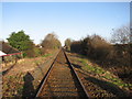
Railway line Coleraine
Looking North from the level crossing at Railway Road.
Image: © Willie Duffin
Taken: 8 Jan 2014
0.17 miles
5
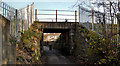
Railway underbridge, Coleraine (5)
A bridge, carrying the Coleraine (right) – Portrush line across a path leading off the Portrush Road.
Image: © Albert Bridge
Taken: 14 Nov 2011
0.18 miles
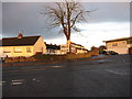
6
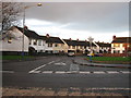
Maple Drive Coleraine
Junction of Maple Drive and the Bushmills road.
Image: © Willie Duffin
Taken: 8 Jan 2014
0.19 miles
7
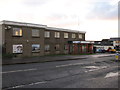
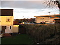
Office block on Bushmills road
This was the main offices of Maxwells Quarries. The red-brick section is now used by the Lakeside development Company as their on-site office.
Image: © Willie Duffin
Taken: 8 Jan 2014
0.20 miles
8
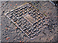
"Plessey" access cover, Coleraine
A “Plessey Automation” access cover on the Portrush Road, just past the corner of the Portstewart Road. It relates (I think) to the controls for the traffic lights there.
Image: © Albert Bridge
Taken: 15 Feb 2013
0.20 miles
9
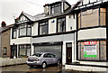
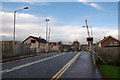
Nos 1-5 Portrush Road, Coleraine
Three properties currently advertised for sale with the following description “Ideal development opportunity subject to the necessary planning approval”. This photograph appears as a matter of record only. I have no connection with any of the parties involved in the sale.
Image: © Albert Bridge
Taken: 29 Jun 2012
0.20 miles
10

Telephone cables, Coleraine
There are still many places where the telephone cables have not been placed underground. This example is on the Portrush Road, just past the corner of the Portstewart Road.
Image: © Albert Bridge
Taken: 15 Feb 2013
0.20 miles