IMAGES TAKEN NEAR TO
The Diamond, COLERAINE, BT52 1HL
Introduction
This page details the photographs taken nearby to The Diamond, BT52 1HL by members of the Geograph project.
The Geograph project started in 2005 with the aim of publishing, organising and preserving representative images for every square kilometre of Great Britain, Ireland and the Isle of Man.

There are currently over 7.5m images from over14,400 individuals and you can help contribute to the project by visiting https://www.geograph.org.uk
Image Map
Images are licensed for reuse under creativecommons.org/licenses/by-sa/2.0
Notes
- Clicking on the map will re-center to the selected point.
- The higher the marker number, the further away the image location is from the centre of the postcode.
Image Listing (416 Images Found)
Images are licensed for reuse under creativecommons.org/licenses/by-sa/2.0
Image
Details
Distance
1
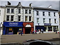
The Works / Ulster Bank, Coleraine
They are located at The Diamond
Image: © Kenneth Allen
Taken: 31 May 2013
0.01 miles
2
![Around The Diamond [2]](https://s2.geograph.org.uk/geophotos/05/50/26/5502686_68b131b9_120x120.jpg)
Around The Diamond [2]
There are a number of lovely buildings around The Diamond. This is Number 24 a bank building from circa 1860. Listed, grade B2, with details at: http://appsc.doeni.gov.uk/buildings/buildview.aspx?id=6864&js=false
Image: © Michael Dibb
Taken: 30 Jul 2017
0.01 miles
3
![Around The Diamond [3]](https://s3.geograph.org.uk/geophotos/05/50/26/5502695_75c8919a_120x120.jpg)
Around The Diamond [3]
There are a number of lovely buildings around The Diamond. This is Number 29 and the Diamond Arcade. The hideous shop front does nothing to enhance a lovely Victorian building.
Image: © Michael Dibb
Taken: 30 Jul 2017
0.01 miles
4
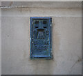
Flush Bracket, Coleraine
Flush bracket bench mark located on the northern side of the old Town Hall in The Diamond, Coleraine Image
The number on the bracket is OSBM 3422.
The mark is 9.04 metres above MSL.
A flush bracket is a type of bench mark set onto the face of a building. See also http://www.geograph.org.uk/search.php?i=11037856 for many other examples I have found.
Image: © Rossographer
Taken: 23 Jul 2011
0.02 miles
5
![Town Hall [1]](https://s1.geograph.org.uk/geophotos/05/50/26/5502637_bc694f81_120x120.jpg)
Town Hall [1]
This lovely Italianate style building was erected in 1859 to replace an earlier market hall. Listed, grade B1, with much detail and history at: http://appsc.doeni.gov.uk/buildings/buildview.aspx?id=6990&js=false
Image: © Michael Dibb
Taken: 30 Jul 2017
0.02 miles
6
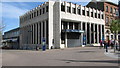
Northern Bank, Coleraine
Situated at the corner of The Diamond and Queen Street
Image: © Willie Duffin
Taken: 9 Apr 2012
0.02 miles
7
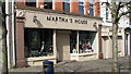
Martha's House, Coleraine
A small interior furnishings shop on Queen Street. A date plaque states 1908.
Image: © Willie Duffin
Taken: 9 Apr 2012
0.02 miles
8
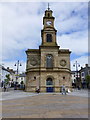
Coleraine Town Hall
See close-up of plaque here Image]
It is located at The Diamond
Image: © Kenneth Allen
Taken: 31 May 2013
0.03 miles
9
![Town Hall [2]](https://s3.geograph.org.uk/geophotos/05/50/33/5503311_0a978454_120x120.jpg)
Town Hall [2]
The Town Hall, and indeed all of The Diamond, is ablaze with flowers.
Image: © Michael Dibb
Taken: 30 Jul 2017
0.03 miles
10
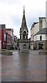
The Orr Monument, Coleraine
Situated in The Diamond.
Image: © Willie Duffin
Taken: 9 Apr 2012
0.03 miles