IMAGES TAKEN NEAR TO
Queen Street, COLERAINE, BT52 1BE
Introduction
This page details the photographs taken nearby to Queen Street, BT52 1BE by members of the Geograph project.
The Geograph project started in 2005 with the aim of publishing, organising and preserving representative images for every square kilometre of Great Britain, Ireland and the Isle of Man.

There are currently over 7.5m images from over14,400 individuals and you can help contribute to the project by visiting https://www.geograph.org.uk
Image Map
Images are licensed for reuse under creativecommons.org/licenses/by-sa/2.0
Notes
- Clicking on the map will re-center to the selected point.
- The higher the marker number, the further away the image location is from the centre of the postcode.
Image Listing (392 Images Found)
Images are licensed for reuse under creativecommons.org/licenses/by-sa/2.0
Image
Details
Distance
1
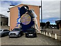
Mural, Coleraine
Pictured along Queen Street
Image: © Kenneth Allen
Taken: 20 Jul 2022
0.00 miles
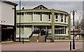
2
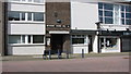
Methodist Church Hall, Coleraine
Church hall and associated buildings on Queen Street.
Image: © Willie Duffin
Taken: 9 Apr 2012
0.00 miles
3
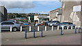
Car-park, Coleraine
A pay and display car-park lying between Circular Road and Queen street. The site was formerly the Lombard Cafe and before that the Temperance Hotel. The site had to be cleared as the roof of the old Cafe had collapsed. Dunnes Supermarket can be seen at the bottom right and also the Methodist Church
Image: © Willie Duffin
Taken: 9 Apr 2012
0.01 miles
4
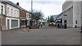
Queen Street, Coleraine
Taken from the Diamond.
Image: © Willie Duffin
Taken: 9 Apr 2012
0.02 miles
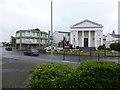
5
Library, Coleraine
Built (as I recall) in the 1960’s when it made quite an architectural impression. It still does although now an accepted part of the streetscape. Very bright and pleasant inside. At the Circular Road end of Queen Street (Abbey Street on the Google map). The satellite photograph shows it as being circular.
Image: © Albert Bridge
Taken: 29 Feb 2012
0.02 miles
6
Methodist Church, Coleraine
Pictured along Circular Road
Image: © Kenneth Allen
Taken: 5 Aug 2014
0.03 miles
7
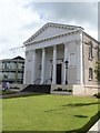
Methodist church
This delightful building was erected in 1854 and substantially renovated in 1993. Listed, grade B+, there is a history of the church at: http://www.causewaymethodistchurches.com/home/coleraine/history
Image: © Michael Dibb
Taken: 30 Jul 2017
0.03 miles
8
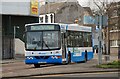
Bus, Coleraine
I have included this Wright-bodied Volvo solely because of its “Merry Christmas” destination indicator.
Image: © Albert Bridge
Taken: 15 Dec 2007
0.03 miles
9
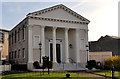
Coleraine Methodist church
Listed (HB03/18/021) church on the Circular Road, built in
1854 with financial assistance, inter alia, from the Honourable the Irish Society and the Worshipful Company of Clothworkers. It replaced one built in 1801 and has more than a passing resemblance to another Image built a few years earlier (1850).
Image: © Albert Bridge
Taken: 14 Nov 2011
0.03 miles
10
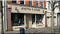
Martha's House, Coleraine
A small interior furnishings shop on Queen Street. A date plaque states 1908.
Image: © Willie Duffin
Taken: 9 Apr 2012
0.03 miles