IMAGES TAKEN NEAR TO
Barnside Road, COLERAINE, BT51 5PD
Introduction
This page details the photographs taken nearby to Barnside Road, BT51 5PD by members of the Geograph project.
The Geograph project started in 2005 with the aim of publishing, organising and preserving representative images for every square kilometre of Great Britain, Ireland and the Isle of Man.

There are currently over 7.5m images from over14,400 individuals and you can help contribute to the project by visiting https://www.geograph.org.uk
Image Map
Images are licensed for reuse under creativecommons.org/licenses/by-sa/2.0
Notes
- Clicking on the map will re-center to the selected point.
- The higher the marker number, the further away the image location is from the centre of the postcode.
Image Listing (3 Images Found)
Images are licensed for reuse under creativecommons.org/licenses/by-sa/2.0
Image
Details
Distance
1
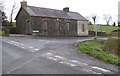
Grove Orange Hall
It is located at the start of the Barnside Road
Image: © Kenneth Allen
Taken: 26 Mar 2008
0.04 miles
2
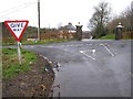
Barnside Road
Approaching the Dullaghy Road
Image: © Kenneth Allen
Taken: 26 Mar 2008
0.04 miles
3
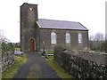
Moyletra Parish Church, Church of Ireland, parish of Desertoghill
It is located on the Kurin Road.
There is a tradition of an ancient church here, but it is surrounded by confusion. The present C of I Moyletra Church is supposed to be a replacement of an earlier church on this site. According to the OS memoirs "tradition says that one of the O'Kahans...was the founder of an ancient church...that formerly stood on the same site where Moyletra Church at present stands. There was a burial ground attached to it".
Image: © Kenneth Allen
Taken: 26 Mar 2008
0.24 miles