IMAGES TAKEN NEAR TO
Strandview Cottages, COLERAINE, BT51 4XS
Introduction
This page details the photographs taken nearby to Strandview Cottages, BT51 4XS by members of the Geograph project.
The Geograph project started in 2005 with the aim of publishing, organising and preserving representative images for every square kilometre of Great Britain, Ireland and the Isle of Man.

There are currently over 7.5m images from over14,400 individuals and you can help contribute to the project by visiting https://www.geograph.org.uk
Image Map
Images are licensed for reuse under creativecommons.org/licenses/by-sa/2.0
Notes
- Clicking on the map will re-center to the selected point.
- The higher the marker number, the further away the image location is from the centre of the postcode.
Image Listing (29 Images Found)
Images are licensed for reuse under creativecommons.org/licenses/by-sa/2.0
Image
Details
Distance
1
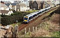
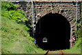
Railway at Castlerock
The 10.40 Belfast – Londonderry approaching the entrance to Castlerock tunnel Image The tunnel is 667 yards long. See also Image
Image: © Albert Bridge
Taken: 18 Mar 2008
0.03 miles
2
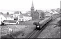
"80" class railcars, Castlerock (1980)
A three-car “80” class set (738,764,92) approaching the entrance to Castlerock tunnel with the 14.10 Belfast Central – Londonderry (via Lisburn). Image shows a similar view in March 2008.
Image: © Albert Bridge
Taken: 8 Mar 1980
0.05 miles
3
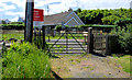
Level crossing, Castlerock
This accommodation crossing is close to the entrance to the tunnel Image on the Castlerock station side. It allows access to the house in the background and is designated “XL 164”.
Image: © Albert Bridge
Taken: 12 Jun 2010
0.05 miles
4
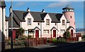
Ocean View, Castlerock
Ocean View is a fairly recent development built on the site of the old library and swimming pool.
Image: © Albert Bridge
Taken: 18 Mar 2008
0.05 miles
5
Railway tunnel, Castlerock
About ¼ mile after Castlerock station Image the railway enters Castlerock tunnel (668 yards). Beyond, after a short spell in the open, it enters the shorter Downhill tunnel (307 yards). The red and white chequered signs indicate restricted clearance (for railway employees). I’m told that there are recesses (once known as “manholes”) inside to allow permanent way staff to shelter in the event of being in the tunnel when a train is passing.
Image: © Albert Bridge
Taken: 12 Jun 2010
0.06 miles
6
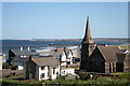
Christ Church, Castlerock from a hill by Tunnel Brae
Image: © Des Colhoun
Taken: 12 May 2009
0.07 miles
7
Spire, Christ Church, Castlerock
Christ Church (CoI) was built in 1868-70 to a design by Frederick William Porter. The spire has Lucifer and clocks (not working) incorporating the Star of David.
Image: © Albert Bridge
Taken: 18 Mar 2008
0.07 miles

9
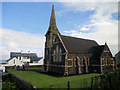
Christ Church, Castlerock
Christ Church, Castlerock was built in 1870. It is typical of the High Victorian interpretation of the Early English Gothic style.
Image: © David Dixon
Taken: 28 Sep 2017
0.08 miles
10
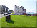
Apartments, Castlerock
Looking west and overlooking the beach
Image: © Kenneth Allen
Taken: 4 Aug 2014
0.08 miles