IMAGES TAKEN NEAR TO
Exorna Lane, COLERAINE, BT51 4UA
Introduction
This page details the photographs taken nearby to Exorna Lane, BT51 4UA by members of the Geograph project.
The Geograph project started in 2005 with the aim of publishing, organising and preserving representative images for every square kilometre of Great Britain, Ireland and the Isle of Man.

There are currently over 7.5m images from over14,400 individuals and you can help contribute to the project by visiting https://www.geograph.org.uk
Image Map
Images are licensed for reuse under creativecommons.org/licenses/by-sa/2.0
Notes
- Clicking on the map will re-center to the selected point.
- The higher the marker number, the further away the image location is from the centre of the postcode.
Image Listing (1 Images Found)
Images are licensed for reuse under creativecommons.org/licenses/by-sa/2.0
Image
Details
Distance
1
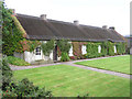
Hezlett House
17th Century thatched cottage and farmyard and one of only a few buildings in Northern Ireland to survive from before the 18th century.
Interesting cruck-truss roof construction
Image: © Kenneth Allen
Taken: 26 Aug 2005
0.15 miles