IMAGES TAKEN NEAR TO
Rockland Park, COLERAINE, BT51 4PL
Introduction
This page details the photographs taken nearby to Rockland Park, BT51 4PL by members of the Geograph project.
The Geograph project started in 2005 with the aim of publishing, organising and preserving representative images for every square kilometre of Great Britain, Ireland and the Isle of Man.

There are currently over 7.5m images from over14,400 individuals and you can help contribute to the project by visiting https://www.geograph.org.uk
Image Map
Images are licensed for reuse under creativecommons.org/licenses/by-sa/2.0
Notes
- Clicking on the map will re-center to the selected point.
- The higher the marker number, the further away the image location is from the centre of the postcode.
Image Listing (4 Images Found)
Images are licensed for reuse under creativecommons.org/licenses/by-sa/2.0
Image
Details
Distance
1
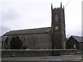
St Mary's Church of Ireland, Macosquin
Located near the centre of the village.
Image: © Kenneth Allen
Taken: 17 Aug 2007
0.16 miles
3

Macosquin: heading for Portush on the A37
A sign on the main road skirting past Macosquin village proclaims a distance of 3 miles to Coleraine and, via the A2, 8 miles to a misspelt Portrush.
Image: © Chris Downer
Taken: 3 Aug 2016
0.18 miles
4
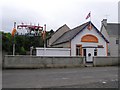
Richardson Memorial Orange Hall, Macosquin
Built in 1915.
Image: © Kenneth Allen
Taken: 17 Aug 2007
0.24 miles