IMAGES TAKEN NEAR TO
Riverside Park North, COLERAINE, BT51 3GE
Introduction
This page details the photographs taken nearby to Riverside Park North, BT51 3GE by members of the Geograph project.
The Geograph project started in 2005 with the aim of publishing, organising and preserving representative images for every square kilometre of Great Britain, Ireland and the Isle of Man.

There are currently over 7.5m images from over14,400 individuals and you can help contribute to the project by visiting https://www.geograph.org.uk
Image Map
Images are licensed for reuse under creativecommons.org/licenses/by-sa/2.0
Notes
- Clicking on the map will re-center to the selected point.
- The higher the marker number, the further away the image location is from the centre of the postcode.
Image Listing (20 Images Found)
Images are licensed for reuse under creativecommons.org/licenses/by-sa/2.0
Image
Details
Distance
1
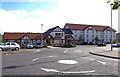
The Riverside & Premier Inn, 3 Riverside Park North, Coleraine
The Riverside is the pub/restaurant part of the adjacent Premier Inn. The Premier Inn chain of hotels offer good quality but economical accommodation.
Image: © P L Chadwick
Taken: 24 Sep 2011
0.04 miles
2
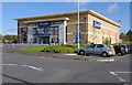
Fitness First, Riverside Park North, Coleraine
A fitness and health club, with personal trainers available if required. Riverside Park North is part of the Riverside Retail Park.
Image: © P L Chadwick
Taken: 24 Sep 2011
0.08 miles
4
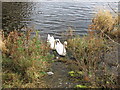
Mute swans on River Bann
This pair are always on the look out for food scraps from passing walkers. The riverside path runs along the edge of the River Bann right into the centre of Coleraine.
Image: © Willie Duffin
Taken: 18 Nov 2012
0.10 miles
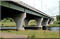
5
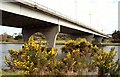
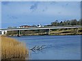
The Sandelford Bridge, Coleraine
See Image The Sandelford Bridge carries the ring road across the Bann. It was the vantage point for Image The river is flowing from right to left.
Image: © Albert Bridge
Taken: 18 Mar 2008
0.13 miles
6
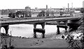
The Sandelford Bridge, Coleraine (3)
The Sandleford Bridge, seen from the eastern side of the Bann. The background is mainly occupied by the now-closed and redeveloped Monsanto factory Image
Image: © Albert Bridge
Taken: 29 Jun 1980
0.14 miles
7
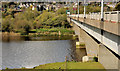
The Sandelford Bridge, Coleraine (2)
The Sandelford Bridge, from the eastern side looking towards the roundabout on the Strand/Castleroe Roads.
Image: © Albert Bridge
Taken: 14 Apr 2012
0.14 miles
8
The Sandelford Bridge, Coleraine (1980)
See Image (March 2008). Some 28 years earlier, the bridge looking exactly the same. The only difference is the growth of whin bushes beside the Bann.
Image: © Albert Bridge
Taken: 29 Jun 1980
0.14 miles
9

Mountsandel Bridge, Coleraine
Looking north from the Bann
Image: © Kenneth Allen
Taken: 17 Aug 2010
0.15 miles