IMAGES TAKEN NEAR TO
Ballykelly Road, LIMAVADY, BT49 9HP
Introduction
This page details the photographs taken nearby to Ballykelly Road, BT49 9HP by members of the Geograph project.
The Geograph project started in 2005 with the aim of publishing, organising and preserving representative images for every square kilometre of Great Britain, Ireland and the Isle of Man.

There are currently over 7.5m images from over14,400 individuals and you can help contribute to the project by visiting https://www.geograph.org.uk
Image Map
Images are licensed for reuse under creativecommons.org/licenses/by-sa/2.0
Notes
- Clicking on the map will re-center to the selected point.
- The higher the marker number, the further away the image location is from the centre of the postcode.
Image Listing (11 Images Found)
Images are licensed for reuse under creativecommons.org/licenses/by-sa/2.0
Image
Details
Distance
1
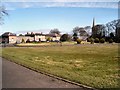
Ballykelly Clinic
The Clinic Ballykelly, a private hospital. It is on the Main Street but set back from the road.
Image: © Kay Atherton
Taken: 4 Apr 2007
0.11 miles
2
Ballykelly Presbyterian Church
The Presbyterian church and graveyard is on the Main Street in Ballykelly on the A2.
Image: © Kay Atherton
Taken: 8 Aug 2007
0.11 miles
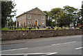
3
Church hall Ballykelly
The hall belonging to the Presbyterian church in Ballykelly, on the Main Street along the A2.
Image: © Kay Atherton
Taken: 8 Aug 2007
0.11 miles
4
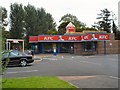
KFC Ballykelly
Among the elegant 18th Century buildings of the pretty village of Ballykelly this looks incongruous. Fortunately someone is trying to grow a high hedge around it.
Image: © Kay Atherton
Taken: 8 Aug 2007
0.11 miles
5
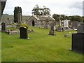
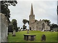
Tamlaghfinlagan graveyard
Part of the old graveyard surrounding the Church of Ireland in the parish of Tamlaghfinlagan in the village of Ballykelly.
Image: © Kay Atherton
Taken: 8 Aug 2007
0.11 miles
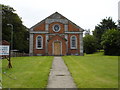
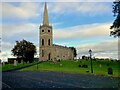
6
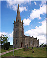
Tamlaght Finlagan Parish Church, Ballykelly
Tamlaght Finlagan Parish Church in the village of Ballykelly. Built in 1795.
Image: © Rossographer
Taken: 12 May 2010
0.18 miles
7
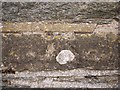
Bench Mark, Ballykelly
Cut bench mark located on Tamlaght Finlagan Parish Church, Ballykelly Image This mark dates from the 1st geodetic levelling of Ireland which took place in 1839-43. The mark is just to the left of the main entrance.
The mark was in a line from Derry/Londonderry to Coleraine via Ballykelly and (Newtown) Limavady; this is actually a Trigonometrical Station in that line.
The original remarks describe it as "Ballykelly Church. Mark on cut stone at West corner of Belfry; 1.6 ft. above sill of South door.
The mark was originally levelled to 76.579 feet above sea level.
Today the mark has been levelled to 20.64 metres above MSL.
See also http://www.geograph.org.uk/search.php?i=11037856 for many other examples I have found.
Image: © Rossographer
Taken: 12 May 2010
0.18 miles
8
Tamlaghfinlagan Parish Church
Tamlaghfinlagan Church of Ireland in the village of Ballykelly, a quiet and peaceful place.
Image: © Kay Atherton
Taken: 8 Aug 2007
0.20 miles
9
Tamlaghfinlagan Parish church and graveyard
The ancient graveyard and Church of Ireland in the parish of Tamlaghfinlagan in Ballykelly.
Image: © Kay Atherton
Taken: 8 Aug 2007
0.20 miles
10
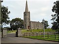
Tamlaghtfinlagan Church Of Ireland Ballykelly
Located off Main Street
Image: © Kenneth Allen
Taken: 4 Nov 2021
0.20 miles