IMAGES TAKEN NEAR TO
Killea Manor, LONDONDERRY, BT48 9XZ
Introduction
This page details the photographs taken nearby to Killea Manor, BT48 9XZ by members of the Geograph project.
The Geograph project started in 2005 with the aim of publishing, organising and preserving representative images for every square kilometre of Great Britain, Ireland and the Isle of Man.

There are currently over 7.5m images from over14,400 individuals and you can help contribute to the project by visiting https://www.geograph.org.uk
Image Map
Images are licensed for reuse under creativecommons.org/licenses/by-sa/2.0
Notes
- Clicking on the map will re-center to the selected point.
- The higher the marker number, the further away the image location is from the centre of the postcode.
Image Listing (4 Images Found)
Images are licensed for reuse under creativecommons.org/licenses/by-sa/2.0
Image
Details
Distance
2
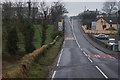
The UK/EU border at Killea
The border at Killea, County Donegal. Northern Ireland (the UK) starts a few feet after the national speed limit sign and as you cross from the Irish Republic (EU), the R237 becomes the B193 (still the Letterkenny Road though). As is common with the border across the island, there is nothing else to mark this transition.
Image: © Rossographer
Taken: 16 Apr 2022
0.05 miles
3
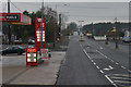
Border Stores, Killea
Service station at Killea, the name derives from its close proximity to the border between north and south Image
Image: © Rossographer
Taken: 16 Apr 2022
0.18 miles