IMAGES TAKEN NEAR TO
Bay Road, LONDONDERRY, BT48 7TG
Introduction
This page details the photographs taken nearby to Bay Road, BT48 7TG by members of the Geograph project.
The Geograph project started in 2005 with the aim of publishing, organising and preserving representative images for every square kilometre of Great Britain, Ireland and the Isle of Man.

There are currently over 7.5m images from over14,400 individuals and you can help contribute to the project by visiting https://www.geograph.org.uk
Image Map
Images are licensed for reuse under creativecommons.org/licenses/by-sa/2.0
Notes
- Clicking on the map will re-center to the selected point.
- The higher the marker number, the further away the image location is from the centre of the postcode.
Image Listing (53 Images Found)
Images are licensed for reuse under creativecommons.org/licenses/by-sa/2.0
Image
Details
Distance

2
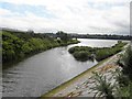
Pennyburn Estuary
The point where the small river enters the Foyle Estuary - it is a favourite spot for bird watchers Image]
Image: © Kenneth Allen
Taken: 1 Aug 2012
0.03 miles

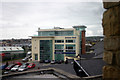


7
Bird watching, Pennyburn
All sorts of birds to be seen here Image]
Image: © Kenneth Allen
Taken: 1 Aug 2012
0.10 miles
8
Information board, Pennyburn Estuary (2)
Pictured here Image]
Image: © Kenneth Allen
Taken: 1 Aug 2012
0.10 miles

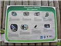
10
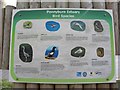
Information board, Pennyburn Estuary (1)
Pictured here Image]
Image: © Kenneth Allen
Taken: 1 Aug 2012
0.10 miles