IMAGES TAKEN NEAR TO
Foyle Road, LONDONDERRY, BT48 6SW
Introduction
This page details the photographs taken nearby to Foyle Road, BT48 6SW by members of the Geograph project.
The Geograph project started in 2005 with the aim of publishing, organising and preserving representative images for every square kilometre of Great Britain, Ireland and the Isle of Man.

There are currently over 7.5m images from over14,400 individuals and you can help contribute to the project by visiting https://www.geograph.org.uk
Image Map
Images are licensed for reuse under creativecommons.org/licenses/by-sa/2.0
Notes
- Clicking on the map will re-center to the selected point.
- The higher the marker number, the further away the image location is from the centre of the postcode.
Image Listing (146 Images Found)
Images are licensed for reuse under creativecommons.org/licenses/by-sa/2.0
Image
Details
Distance
1
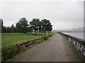
Londonderry and Enniskillen Railway
The route of the Londonderry and Enniskillen Railway is now a walkway alongside the River Foyle and some track has been relaid as part of the Foyle Valley Railway Museum. The Craigavon Bridge can be seen in the background.
Image: © Richard Webb
Taken: 18 Jul 2012
0.05 miles
2
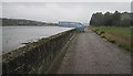
Bridge to nowhere
Some ironwork cantilevered over the River Foyle at the Foyle Valley Railway Museum.
There is a cycle/footpath along the trackbed of the Londonderry and Enniskillen Railway with some overgrown tracks belonging to the Foyle Valley Railway Museum.
Image: © Richard Webb
Taken: 18 Jul 2012
0.07 miles
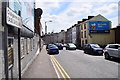
4
Abercorn Road, Derry / Londonderry
Heading west
Image: © Kenneth Allen
Taken: 1 Aug 2012
0.09 miles
5
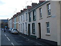
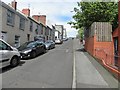
Mary Street, Londonderry.
Mary Street, Londonderry. Marked on the OS map as Hiller Street. The opposite side of this street is known as Cooke Terrace. the street which runs vertically to this, from where this photo was taken is known as Miller Street.
Image: © David Laverty
Taken: 2 Mar 2007
0.10 miles
6
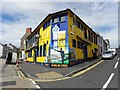
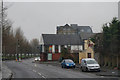
Abercorn Bar, Derry / Londonderry
It is located at the corner of Abercorn Road and Bennett Street
Image: © Kenneth Allen
Taken: 1 Aug 2012
0.10 miles
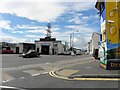
7
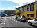
Bennett Street, Derry / Londonderry
Heading SSE towards Abercorn Road
Image: © Kenneth Allen
Taken: 1 Aug 2012
0.10 miles
8
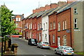
Moat Street: Derry
Just off Foyle Road and beside the Star Shirt Factory building.
Image: © louise price
Taken: 10 Jun 2009
0.10 miles
9
Bennett Street
Heading north-west towards Bishop Street
Image: © Kenneth Allen
Taken: 1 Aug 2012
0.12 miles
10
Abercorn Road, Derry / Londonderry
Heading south-east from Bishop Street Without
Image: © Kenneth Allen
Taken: 22 May 2019
0.12 miles