IMAGES TAKEN NEAR TO
Foyle Road, LONDONDERRY, BT48 6SQ
Introduction
This page details the photographs taken nearby to Foyle Road, BT48 6SQ by members of the Geograph project.
The Geograph project started in 2005 with the aim of publishing, organising and preserving representative images for every square kilometre of Great Britain, Ireland and the Isle of Man.

There are currently over 7.5m images from over14,400 individuals and you can help contribute to the project by visiting https://www.geograph.org.uk
Image Map
Images are licensed for reuse under creativecommons.org/licenses/by-sa/2.0
Notes
- Clicking on the map will re-center to the selected point.
- The higher the marker number, the further away the image location is from the centre of the postcode.
Image Listing (338 Images Found)
Images are licensed for reuse under creativecommons.org/licenses/by-sa/2.0
Image
Details
Distance
1

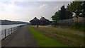
View from the A2 Bridge Derry
River Foyle
https://en.wikipedia.org/wiki/River_Foyle
Image: © James Emmans
Taken: 10 Sep 2015
0.01 miles
2
Londonderry Old Railway Line
Railway line running along the river edge.
Image: © James Emmans
Taken: 10 Sep 2015
0.01 miles
3
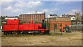
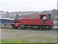
Red Steam Engine - Londonderry Preserved Railway
This train in the original red livery was used on the Londonderry and Enniskillen Railway. The line closed in 1957 by the government.
https://en.wikipedia.org/wiki/Londonderry_and_Enniskillen_Railway
Image: © James Emmans
Taken: 10 Sep 2015
0.01 miles
4
Foyle Valley Railway Museum
It is located on the city side of Craigavon Bridge in Derry / Londonderry. The line used to run to Carrigans, County Donegal
Image: © Kenneth Allen
Taken: 23 Mar 2006
0.02 miles
5
Craigavon Bridge, Derry / Londonderry
The handsome two-level Craigavon Bridge (400yd/365m long), opened by the Lord Mayor of London in 1933, leads over the Foyle to a new and modern suburb of the city to the southeast.
Image: © Kenneth Allen
Taken: 23 Mar 2006
0.02 miles
6
Train at Derry / Londonderry
Not much chance of this getting back on track
Image: © Kenneth Allen
Taken: 23 Mar 2006
0.02 miles
7
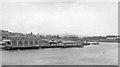
Londonderry: across River Foyle from Craigavon Bridge, 1960
View over the Foyle Estuary to Abercorn Quay and the western part of Derry. Terminal buildings of the ex-Great Northern (Ireland) lines from Dublin and Belfast via Omagh, which closed 15/2/65, are seen by the Quay. Until about the mid-fifties there was also a rail connection northward with the former Londonderry & Loch Swilly system that termiated there its lines from Burtonpoint, Buncrana and Cardonagh. Until 1/1/55 trains of the County Donegal Joint Railway had also come in from the southern direction from Strabane. Off the view to the left on that side nowadays is Foyle Valley Railway Museum.
Image: © Ben Brooksbank
Taken: 10 Aug 1960
0.02 miles
8
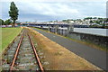
Old Railway at Foyle Road
The railway from Donegal as it approaches the station at Foyle Road, now a museum, with Craigavon Bridge beyond.
Image: © louise price
Taken: 10 Jun 2009
0.03 miles
9
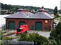
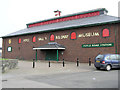
Railway Station Museum, Derry / Londonderry
It is located along Foyle Road
The train was one of my early submissions - Image]
Image: © Kenneth Allen
Taken: 6 Aug 2010
0.04 miles
10

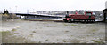
Foyle Valley Railway station and sheds, Derry, Co. Londonderry
Image: © nick macneill
Taken: 22 Jun 1999
0.04 miles