Londonderry: across River Foyle from Craigavon Bridge, 1960
Introduction
The photograph on this page of Londonderry: across River Foyle from Craigavon Bridge, 1960 by Ben Brooksbank as part of the Geograph project.
The Geograph project started in 2005 with the aim of publishing, organising and preserving representative images for every square kilometre of Great Britain, Ireland and the Isle of Man.

There are currently over 7.5m images from over 14,400 individuals and you can help contribute to the project by visiting https://www.geograph.org.uk
Londonderry: across River Foyle from Craigavon Bridge, 1960
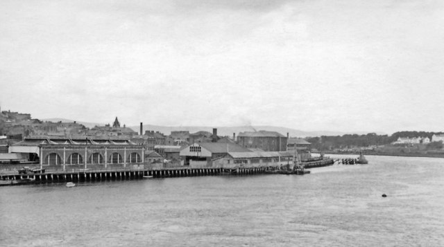
Image: © Ben Brooksbank Taken: 10 Aug 1960
View over the Foyle Estuary to Abercorn Quay and the western part of Derry. Terminal buildings of the ex-Great Northern (Ireland) lines from Dublin and Belfast via Omagh, which closed 15/2/65, are seen by the Quay. Until about the mid-fifties there was also a rail connection northward with the former Londonderry & Loch Swilly system that termiated there its lines from Burtonpoint, Buncrana and Cardonagh. Until 1/1/55 trains of the County Donegal Joint Railway had also come in from the southern direction from Strabane. Off the view to the left on that side nowadays is Foyle Valley Railway Museum.
Images are licensed for reuse under creativecommons.org/licenses/by-sa/2.0
Image Location
Latitude
54.990497
Longitude
-7.321181