IMAGES TAKEN NEAR TO
Ferryquay Street, LONDONDERRY, BT48 6JB
Introduction
This page details the photographs taken nearby to Ferryquay Street, BT48 6JB by members of the Geograph project.
The Geograph project started in 2005 with the aim of publishing, organising and preserving representative images for every square kilometre of Great Britain, Ireland and the Isle of Man.

There are currently over 7.5m images from over14,400 individuals and you can help contribute to the project by visiting https://www.geograph.org.uk
Image Map
Images are licensed for reuse under creativecommons.org/licenses/by-sa/2.0
Notes
- Clicking on the map will re-center to the selected point.
- The higher the marker number, the further away the image location is from the centre of the postcode.
Image Listing (1298 Images Found)
Images are licensed for reuse under creativecommons.org/licenses/by-sa/2.0
Image
Details
Distance
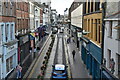
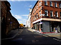
2
Ferryquay Street, Derry / Londonderry
Heading north-west towards The Diamond
Image: © Kenneth Allen
Taken: 11 May 2017
0.01 miles
3
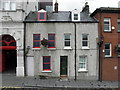
House with virtual front, Derry / Londonderry
Pictured along Artillery Street
Image: © Kenneth Allen
Taken: 6 Aug 2015
0.01 miles
4
Ferryquay Street, Derry / Londonderry
Heading north-west from Artillery Street and Market Street
Image: © Kenneth Allen
Taken: 6 Aug 2015
0.01 miles
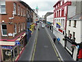
5
Ferryquay Street, Derry / Londonderry
Heading south-east
Image: © Kenneth Allen
Taken: 1 Aug 2012
0.01 miles
6
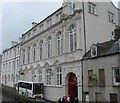
The Playhouse Community Centre, Artillery Street, Derry
The Playhouse set up in former Convent Primary School buildings within the historic walled city of Derry uses the arts to address a range of social needs in the area, including cross-community relations, job creation, educational performance and the development of alternative curriculums for young people.
Image: © Eric Jones
Taken: 19 Aug 2009
0.01 miles
7
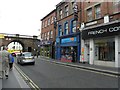
Shops in Ferryquay Street, Derry
The city wall is here crossed by Ferryquay Street. The shop buildings were built in the period of rapid redevelopment which followed the Peace Agreement.
Image: © Eric Jones
Taken: 23 Jul 2012
0.01 miles
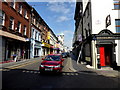
8
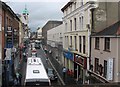
Ferry Quay Street, Londonderry/Derry
This heavily congested street leads from the Ferry Quay Gate to The Diamond - at the centre of the walled town.
Image: © Eric Jones
Taken: 19 Aug 2009
0.02 miles
9

The Playhouse, Derry / Londonderry
Located along Artillery Street, it has been described as one of the most dynamic and creative Arts Centres in Northern Ireland
See close-up of plaque here Image]
Image: © Kenneth Allen
Taken: 8 Jul 2013
0.02 miles
10
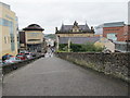
Artillery Street, Derry / Londonderry
Looking SSW from Ferryquay Street
Image: © Kenneth Allen
Taken: 11 May 2017
0.02 miles