IMAGES TAKEN NEAR TO
Dunnalong Road, LONDONDERRY, BT47 2RU
Introduction
This page details the photographs taken nearby to Dunnalong Road, BT47 2RU by members of the Geograph project.
The Geograph project started in 2005 with the aim of publishing, organising and preserving representative images for every square kilometre of Great Britain, Ireland and the Isle of Man.

There are currently over 7.5m images from over14,400 individuals and you can help contribute to the project by visiting https://www.geograph.org.uk
Image Map
Images are licensed for reuse under creativecommons.org/licenses/by-sa/2.0
Notes
- Clicking on the map will re-center to the selected point.
- The higher the marker number, the further away the image location is from the centre of the postcode.
Image Listing (2 Images Found)
Images are licensed for reuse under creativecommons.org/licenses/by-sa/2.0
Image
Details
Distance
1
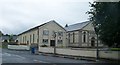
The Presbyterian Church and Vestry at Magheramason
Magheramason is a largely Protestant and Loyalist community. The Presbyterian church built in the 1870s is the main hub of community life.
Image: © Eric Jones
Taken: 23 Jul 2012
0.18 miles
2
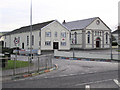
Magheramason Presbyterian Church and Hall
These very neat looking buildings at Magheramason are on the main road between Strabane and Londonderry (The church is on the right)
At the laying of the foundation stone in September 1958, the son of the building firm, Joseph Crawford & Sons presented a silver trowel in commemoration of the event. Ministers present were Rev Dr FWC Wallace MA, minister of Magheramason Presbyterian Church, the Moderator of the Derry Presbytery Rev SM McSparron BA, Monreagh, Carrigans and Councillor SS Dowds CBE JP
Image: © Kenneth Allen
Taken: 21 Dec 2005
0.18 miles