IMAGES TAKEN NEAR TO
Virginia Court, LONDONDERRY, BT47 2DX
Introduction
This page details the photographs taken nearby to Virginia Court, BT47 2DX by members of the Geograph project.
The Geograph project started in 2005 with the aim of publishing, organising and preserving representative images for every square kilometre of Great Britain, Ireland and the Isle of Man.

There are currently over 7.5m images from over14,400 individuals and you can help contribute to the project by visiting https://www.geograph.org.uk
Image Map
Images are licensed for reuse under creativecommons.org/licenses/by-sa/2.0
Notes
- Clicking on the map will re-center to the selected point.
- The higher the marker number, the further away the image location is from the centre of the postcode.
Image Listing (5 Images Found)
Images are licensed for reuse under creativecommons.org/licenses/by-sa/2.0
Image
Details
Distance
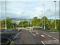
1
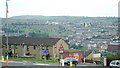
'Top of the Hill': Gobnascale
A housing estate on Derry's Waterside with a great view of the city below.
Image: © louise price
Taken: 9 Aug 2009
0.12 miles
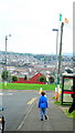
2
Gobnascale Area
The view is looking down towards the centre of Derry / Londonderry.
Image: © Kenneth Allen
Taken: 18 Jan 2006
0.13 miles
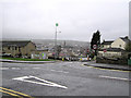
3
Strabane Old Road, Waterside
Gobnascale - in Derry's Waterside.
Image: © Dean Molyneaux
Taken: 23 Jul 2009
0.19 miles
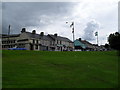
4
Gobnascale or 'Top of the Hill'
A housing estate located on a hill on the Waterside area of Derry; in the distance, this view is looking towards Creggan on the City Side.
Image: © louise price
Taken: 9 Aug 2009
0.19 miles