IMAGES TAKEN NEAR TO
Lisheen Park, BALLYMENA, BT44 8QN
Introduction
This page details the photographs taken nearby to Lisheen Park, BT44 8QN by members of the Geograph project.
The Geograph project started in 2005 with the aim of publishing, organising and preserving representative images for every square kilometre of Great Britain, Ireland and the Isle of Man.

There are currently over 7.5m images from over14,400 individuals and you can help contribute to the project by visiting https://www.geograph.org.uk
Image Map
Images are licensed for reuse under creativecommons.org/licenses/by-sa/2.0
Notes
- Clicking on the map will re-center to the selected point.
- The higher the marker number, the further away the image location is from the centre of the postcode.
Image Listing (4 Images Found)
Images are licensed for reuse under creativecommons.org/licenses/by-sa/2.0
Image
Details
Distance
2
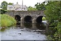
Glenone Bridge over Clady River
The Glenone Bridge is on Moneygram Road (A54) (sometimes called Kilrea Road) a short distance (say 100 metres) from the intersection with Clady Road (A42) in Glenone, County Londonderry, Northern Ireland. This photo was taken from the west side of the bridge, looking north-east. The building in the background is a modern house on the other side (east side) of Moneygran Road (Kilrea Road). Nearest village is Clady, County Londonderry. The nearest main township is Portglenone.
Image: © Peter Keenan
Taken: 15 Aug 2018
0.17 miles
3
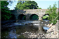
Glenone bridge over the Clady River
On this bridge the A54 Portglenone to Kilrea road crosses the Clady River, a significant tributary of the nearby River Bann.
Image: © Cormac Duffin
Taken: 9 Jun 2007
0.19 miles
4
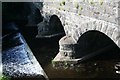
Glenone Bridge close-up
Another shot of the Kilrea line bridge over the Clady in Glenone.
Image: © Cormac Duffin
Taken: 9 Jun 2007
0.19 miles