IMAGES TAKEN NEAR TO
Kilnadore Brae, BALLYMENA, BT44 0NP
Introduction
This page details the photographs taken nearby to Kilnadore Brae, BT44 0NP by members of the Geograph project.
The Geograph project started in 2005 with the aim of publishing, organising and preserving representative images for every square kilometre of Great Britain, Ireland and the Isle of Man.

There are currently over 7.5m images from over14,400 individuals and you can help contribute to the project by visiting https://www.geograph.org.uk
Image Map
Images are licensed for reuse under creativecommons.org/licenses/by-sa/2.0
Notes
- Clicking on the map will re-center to the selected point.
- The higher the marker number, the further away the image location is from the centre of the postcode.
Image Listing (42 Images Found)
Images are licensed for reuse under creativecommons.org/licenses/by-sa/2.0
Image
Details
Distance
2
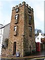
Wall Painting, Cushendall
Looking seaward. The painting celebrates Hurling and includes the Curfew Tower, built by Francis Turnley, in 1817, to confine riotous prisoners
Image: © Bob Embleton
Taken: 23 Aug 2006
0.18 miles
3
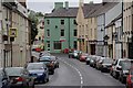
Cushendall
This is Chapel Road or The Antrim Coast Road (A2) where it passes through Cushedall.
Image: © Paul McIlroy
Taken: 17 May 2007
0.18 miles
4
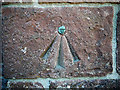
Bench Mark, Cushendall
A bolt bench mark set into Layde Church of Ireland, Mill Street, Cushendall. The bolt is on the north-eastern corner of the church. This dates from the 1st levelling of Ireland which took place in 1839-43. The mark was in a line from Belfast to Portrush which began at Commercial Buildings in Belfast - see Image; this is actually a Trigonometrical Station in that line.
The original remarks for the levelling of Ireland describe it as:
"Cushendall New Church. Copper bolt driven into North-west coinstone; 2.8 feet above surface" (this may be incorrect, as it is on the north-eastern corner of the church). It was initially levelled to 37.462 feet above sea level.
Today the mark has been levelled to 8.80 metres above MSL.
See also http://www.geograph.org.uk/search.php?i=11037856 for many other examples I have found.
Image: © Rossographer
Taken: 19 Jun 2010
0.20 miles
5
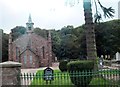
Cushendall Parish Church (CoI)
The church which backs on to the River Dall is situated at the western outskirts of the town.
Image: © Eric Jones
Taken: 26 Sep 2013
0.21 miles
6
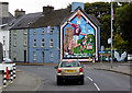
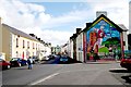
Hurling Mural at Cushendall
Cushendall (from Irish Cois Abhann Dalla, meaning 'foot of the River Dall'), formerly known as Newtown Glens, is a village and townland in County Antrim, on the A2 coast road between Glenariff and Cushendun, in the Antrim Coast and Glens Area of Outstanding Natural Beauty. In the 2001 Census it had a population of 1,241 people, with a 2008 estimate of 1,363 (Wikipedia).
This large mural on the gable end of the Antrim Coast Apartments is dedicated to the local club, Ruairí Óg's, which plays its home matches at Páirc Mhuire in Cushendall. The club was founded in 1906.
Image: © David Dixon
Taken: 28 Sep 2017
0.21 miles
7
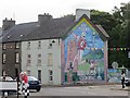
Mural, Cushendall
Celebrating the centenary of Ruairí Óg CLG which was founded in 1906.
Image: © Richard Webb
Taken: 5 Aug 2013
0.21 miles
8
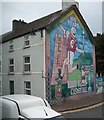
The Ruairi Og GLC Mural in Ballybrack Road, Cushendall
Cushendall has a long and successful history of success in the field Gaelic Games including hurling and camogie. The team colours are maroon and white. The particular game depicted in this mural is hurling. The team's home ground is Pairc Mhuire.
http://en.wikipedia.org/wiki/Hurling
Image]
Image: © Eric Jones
Taken: 26 Sep 2013
0.21 miles
9
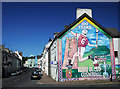
Mill Street, Cushendall
Mill Street in the village of Cushendall. The mural on the right celebrates the local hurling team, Ruairí Óg - see http://www.ruairiog.com/ .
Image: © Rossographer
Taken: 19 Jun 2010
0.21 miles
10
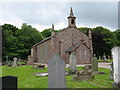
Church of Ireland, Cushendall, Co. Antrim
Image: © Dr Neil Clifton
Taken: 19 Jun 2009
0.21 miles