IMAGES TAKEN NEAR TO
Garron Road, BALLYMENA, BT44 0JU
Introduction
This page details the photographs taken nearby to Garron Road, BT44 0JU by members of the Geograph project.
The Geograph project started in 2005 with the aim of publishing, organising and preserving representative images for every square kilometre of Great Britain, Ireland and the Isle of Man.

There are currently over 7.5m images from over14,400 individuals and you can help contribute to the project by visiting https://www.geograph.org.uk
Image Map
Images are licensed for reuse under creativecommons.org/licenses/by-sa/2.0
Notes
- Clicking on the map will re-center to the selected point.
- The higher the marker number, the further away the image location is from the centre of the postcode.
Image Listing (21 Images Found)
Images are licensed for reuse under creativecommons.org/licenses/by-sa/2.0
Image
Details
Distance
1
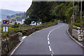
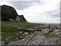
Garron Point
Looking south along the coast
Image: © Kenneth Allen
Taken: 1 Jul 2010
0.02 miles
2
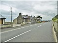
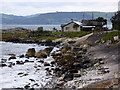
Garron, cottages
Former coastguard cottages at Garron Point, on A2 (Causeway Coastal Route).
Image: © Mike Faherty
Taken: 20 Jun 2018
0.03 miles
3
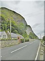
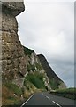
Garron, cliff
On A2 (Causeway Coastal Route). A dramatic cliff, clearly showing basalt strata at the top, and Cretaceous limestone lower down. Note, the cliff is netted!
Image: © Mike Faherty
Taken: 20 Jun 2018
0.04 miles
5
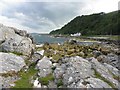
House at Garron Point
Rocky shoreline at Garron Point.
Image: © David Dixon
Taken: 28 Sep 2017
0.05 miles
6
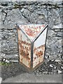
Old Milepost by the A2, Garron Road, Garron Point
Cast iron milepost with iron attachments on the A2, in the townland of Galboly Lower; Garron Point, opposite cottages against stone wall, West side of road. Erected by the county, C19.
Inscription reads:- : CUSHEN / DALL / 6¼ / MILES : : GLENARM / 7 / MILES : : BELFAST / 43 :
Milestone Society National ID: ANT_BFBC43.
Image: © Milestone Society
Taken: 20 Jun 2018
0.05 miles
7
Chalk cliffs above the Garron Road (A2)
MacNissi's College - a Catholic school is on the shelf above these cliffs.
http://www.habitas.org.uk/escr/summary.asp?item=1212
Image: © Eric Jones
Taken: 13 Aug 2011
0.05 miles
8
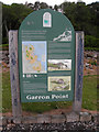
Information board, Garron Point
Pictured at the car park
Image: © Kenneth Allen
Taken: 1 Jul 2010
0.08 miles
9
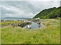
Garron, quay
Presumably once used by coastguards stationed at Image
Image: © Mike Faherty
Taken: 20 Jun 2018
0.10 miles