IMAGES TAKEN NEAR TO
Garron Road, BALLYMENA, BT44 0JT
Introduction
This page details the photographs taken nearby to Garron Road, BT44 0JT by members of the Geograph project.
The Geograph project started in 2005 with the aim of publishing, organising and preserving representative images for every square kilometre of Great Britain, Ireland and the Isle of Man.

There are currently over 7.5m images from over14,400 individuals and you can help contribute to the project by visiting https://www.geograph.org.uk
Image Map
Images are licensed for reuse under creativecommons.org/licenses/by-sa/2.0
Notes
- Clicking on the map will re-center to the selected point.
- The higher the marker number, the further away the image location is from the centre of the postcode.
Image Listing (17 Images Found)
Images are licensed for reuse under creativecommons.org/licenses/by-sa/2.0
Image
Details
Distance
1
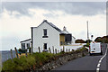
Coastal Cottages
A couple of cottages on the coast road.
Image: © David Dixon
Taken: 28 Sep 2017
0.01 miles
2
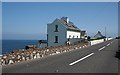
Ardclinis
Two of the three cottages perched between the A2 road and the shore here seem to be available for holiday lets.
Image: © Anne Burgess
Taken: 7 Jun 2007
0.05 miles
3
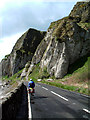
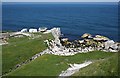
Chalk cliffs at Garronpoint
The Antrim Coast Road was constructed in 1842 and is one of the most spectacular roads in Ireland, hugging the coast for about 35 miles from Larne to Cushendall. Because of frequent rock falls along this stretch the road was closed in 2010 for eight weeks while safety nets were fitted to prevent rocks falling on to the road. The main A2 continues from just before Cushendun to Ballycastle on an inland stretch via Ballypatrick but it is possible to continue via the coastal route on the steep, narrow and winding Torr Rd to Torr Head, considered a challenge by 4x4 drivers and cyclists though not recommended if towing a caravan.
Image: © Robert Ashby
Taken: 3 May 2004
0.05 miles
5
Quay
This quay was presumably where the quarry products from the huge Garron Point quarry were loaded for shipment by sea.
Image: © Anne Burgess
Taken: 7 Jun 2007
0.10 miles
6
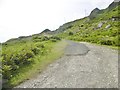
Glenariff, track
From Garron Road up the cliff to Galboly.
Image: © Mike Faherty
Taken: 23 Jun 2018
0.12 miles
7
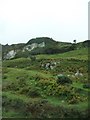
Quarry road leading from the A2 at Galboly
Outcrops of chalk can be seen on the hill side.
Image: © Eric Jones
Taken: 26 Sep 2013
0.17 miles
8
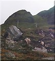
Scree fan, Galboly
Basalt screes beneath a gap in the lower tier of chalk crags.
Image: © Richard Webb
Taken: 5 Aug 2013
0.18 miles
9
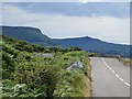
A2, Galboly
The coast road beneath fine basalt and chalk crags.
Image: © Richard Webb
Taken: 29 Jul 2013
0.18 miles
10
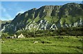
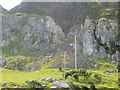
Black and White cliffs at Galboly, Antrim Coast Road
This is probably the most spectacular part of the coast road. The 80 million year old Chalk is overlain by 60 million year old basalt lava flows.
Image: © Mike Simms
Taken: 6 Jul 2002
0.18 miles