IMAGES TAKEN NEAR TO
Largy Road, BALLYMENA, BT44 0JL
Introduction
This page details the photographs taken nearby to Largy Road, BT44 0JL by members of the Geograph project.
The Geograph project started in 2005 with the aim of publishing, organising and preserving representative images for every square kilometre of Great Britain, Ireland and the Isle of Man.

There are currently over 7.5m images from over14,400 individuals and you can help contribute to the project by visiting https://www.geograph.org.uk
Image Map
Images are licensed for reuse under creativecommons.org/licenses/by-sa/2.0
Notes
- Clicking on the map will re-center to the selected point.
- The higher the marker number, the further away the image location is from the centre of the postcode.
Image Listing (6 Images Found)
Images are licensed for reuse under creativecommons.org/licenses/by-sa/2.0
Image
Details
Distance
1
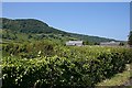
Largy
New houses just off the Largy Road, which runs between green fields and hedges along a level area above the coast road. The hill in the background is Binabanan.
Image: © Anne Burgess
Taken: 7 Jun 2007
0.13 miles
2
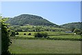
Broken Bridge
Looking inland from near Broken Bridge across the fields. Binabanan is the hill in the background. It is in the next square.
Image: © Anne Burgess
Taken: 7 Jun 2007
0.15 miles
3
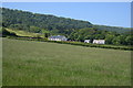
Broken Bridge
New houses among the fields north of Carnlough. I don't know the significance of the name Broken Bridge, but that's what the map says.
Image: © Anne Burgess
Taken: 7 Jun 2007
0.19 miles
4
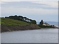
Carnlough, coastline
Looking towards Ringfad Rocks on the Causeway Coastal Route.
Image: © Mike Faherty
Taken: 20 Jun 2018
0.24 miles
5
House, Garron Road
View up the A2 with Kintyre in the background.
Image: © Richard Webb
Taken: 29 Jul 2013
0.24 miles
6
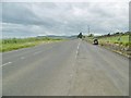
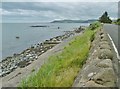
Carnlough, A2
Garron Road, A2, on the Causeway Coastal Route; one of the many lay-bys in this section.
Image: © Mike Faherty
Taken: 20 Jun 2018
0.25 miles