IMAGES TAKEN NEAR TO
Cranny View, BALLYMENA, BT44 0JA
Introduction
This page details the photographs taken nearby to Cranny View, BT44 0JA by members of the Geograph project.
The Geograph project started in 2005 with the aim of publishing, organising and preserving representative images for every square kilometre of Great Britain, Ireland and the Isle of Man.

There are currently over 7.5m images from over14,400 individuals and you can help contribute to the project by visiting https://www.geograph.org.uk
Image Map
Images are licensed for reuse under creativecommons.org/licenses/by-sa/2.0
Notes
- Clicking on the map will re-center to the selected point.
- The higher the marker number, the further away the image location is from the centre of the postcode.
Image Listing (21 Images Found)
Images are licensed for reuse under creativecommons.org/licenses/by-sa/2.0
Image
Details
Distance
1
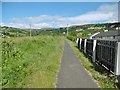
Carnlough, Hurry Path
On the trackbed of a mineral railway from nearby quarries to the harbour.
Image: © Mike Faherty
Taken: 22 Jun 2018
0.05 miles
2
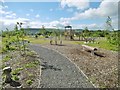
Carnlough, park
Carnlough Natural Play Park, a gem on the Hurry Path.
Image: © Mike Faherty
Taken: 20 Jun 2018
0.10 miles
3
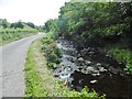
Carnlough, Carnlough River
Looking downstream from Waterfall Road.
Image: © Mike Faherty
Taken: 22 Jun 2018
0.11 miles
4
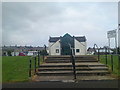
Glenlough Community Centre
Glenlough Community Centre in Carnlough.It was built in 1996 and is used for local community activities.
Image: © Paul L
Taken: 18 May 2009
0.16 miles
5
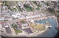
Carnlough Village and Harbour
Taken from helicopter overlooking Carnlough Harbour, Harbour Road, Largy Road, Croft Road and High Street.
Image: © Ian W Scroggy
Taken: Unknown
0.17 miles
6
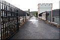
Old railway bridge, Carnlough (2)
See Image The bridge is now a public footpath. This is the view towards the old quarries.
Image: © Albert Bridge
Taken: 14 May 2007
0.17 miles
7
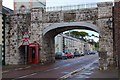
Old railway bridge, Carnlough (1)
There were three limestone quarries to the west and south of Carnlough. The product was conveyed, to the harbour, by railway. Two of the lines were narrow 3ft 6 gauge. The other was of narrow (by Irish standards) 4ft 8½ gauge. They operated between 1853 and 1922. The bridge is of limestone construction.
Image: © Albert Bridge
Taken: 14 May 2007
0.17 miles
8
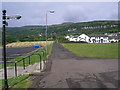
Course of former mineral railway, Carnlough, Co. Antrim
This shows the course of the railway which was formerly used to convey stone from a quarry some distance away, to the harbour for export. The line was worked mostly by gravity on the counterbalance principle, but a steam locomotive was employed at the harbour end to shunt the wagons.
Image: © Dr Neil Clifton
Taken: 19 Jun 2009
0.18 miles
9
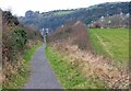
Old railway, Carnlough
See Image The old railway to the quarry is now a path. The cutting is a clue to its origins.
Image: © Albert Bridge
Taken: 15 Feb 2008
0.21 miles
10

Carnlough Methodist Church
Carnlough Methodist Church situated in Herbert Street. There is a new housing developments around the church. The plaque above the door reads Methodist Church Erected 1858.
Image: © Paul L
Taken: 21 Jun 2009
0.23 miles