IMAGES TAKEN NEAR TO
Drumourne Road, BALLYMENA, BT44 0HX
Introduction
This page details the photographs taken nearby to Drumourne Road, BT44 0HX by members of the Geograph project.
The Geograph project started in 2005 with the aim of publishing, organising and preserving representative images for every square kilometre of Great Britain, Ireland and the Isle of Man.

There are currently over 7.5m images from over14,400 individuals and you can help contribute to the project by visiting https://www.geograph.org.uk
Image Map
Images are licensed for reuse under creativecommons.org/licenses/by-sa/2.0
Notes
- Clicking on the map will re-center to the selected point.
- The higher the marker number, the further away the image location is from the centre of the postcode.
Image Listing (4 Images Found)
Images are licensed for reuse under creativecommons.org/licenses/by-sa/2.0
Image
Details
Distance
1
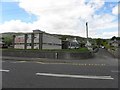
Saint John's Primary School and Carnlough Community Nursery
It is located along Bay Road
Image: © Kenneth Allen
Taken: 2 Jun 2010
0.21 miles
2
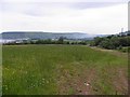
White Hill, Carnlough
Looking SSE in the direction of Drumnacole
Image: © Kenneth Allen
Taken: 30 Jun 2010
0.21 miles
3
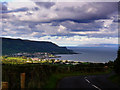
View of Carnlough from the Ballyvaddy Road
Carnlough bathed in sunlight and the east Antrim coast with the Mull of Kintyre in Scotland in the distance. This area from western Scotland and including most of Co Antrim formed the ancient Kingdom Of Dalriada. The sea channel, far from being a barrier, was used as a highway by ancient peoples.
Image: © Robert Ashby
Taken: 4 Aug 2005
0.22 miles
4
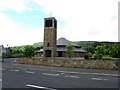
St John's RC Church, Carnlough
It is located along Bay Road
Image: © Kenneth Allen
Taken: 2 Jun 2010
0.23 miles