IMAGES TAKEN NEAR TO
Whitehill Road, BALLYMENA, BT44 0HG
Introduction
This page details the photographs taken nearby to Whitehill Road, BT44 0HG by members of the Geograph project.
The Geograph project started in 2005 with the aim of publishing, organising and preserving representative images for every square kilometre of Great Britain, Ireland and the Isle of Man.

There are currently over 7.5m images from over14,400 individuals and you can help contribute to the project by visiting https://www.geograph.org.uk
Image Map
Images are licensed for reuse under creativecommons.org/licenses/by-sa/2.0
Notes
- Clicking on the map will re-center to the selected point.
- The higher the marker number, the further away the image location is from the centre of the postcode.
Image Listing (5 Images Found)
Images are licensed for reuse under creativecommons.org/licenses/by-sa/2.0
Image
Details
Distance
1
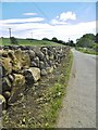
Carnlough, wall
A new dry-stone wall on Waterfall Road. Large limestone boulders at the base, smaller basalt stones at the top.
Image: © Mike Faherty
Taken: 22 Jun 2018
0.21 miles
2
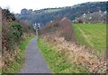
Old railway, Carnlough
See Image The old railway to the quarry is now a path. The cutting is a clue to its origins.
Image: © Albert Bridge
Taken: 15 Feb 2008
0.22 miles
3
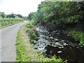
Carnlough, Carnlough River
Looking downstream from Waterfall Road.
Image: © Mike Faherty
Taken: 22 Jun 2018
0.22 miles
4
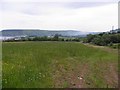
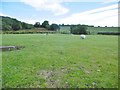
White Hill, Carnlough
Looking SSE in the direction of Drumnacole
Image: © Kenneth Allen
Taken: 30 Jun 2010
0.23 miles