IMAGES TAKEN NEAR TO
Bellisk Drive, BALLYMENA, BT44 0AX
Introduction
This page details the photographs taken nearby to Bellisk Drive, BT44 0AX by members of the Geograph project.
The Geograph project started in 2005 with the aim of publishing, organising and preserving representative images for every square kilometre of Great Britain, Ireland and the Isle of Man.

There are currently over 7.5m images from over14,400 individuals and you can help contribute to the project by visiting https://www.geograph.org.uk
Image Map
Images are licensed for reuse under creativecommons.org/licenses/by-sa/2.0
Notes
- Clicking on the map will re-center to the selected point.
- The higher the marker number, the further away the image location is from the centre of the postcode.
Image Listing (24 Images Found)
Images are licensed for reuse under creativecommons.org/licenses/by-sa/2.0
Image
Details
Distance
1
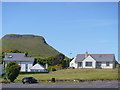
Houses with a view
The houses are in Glenariff Road and have an excellent view of the Irish Sea to Scotland. In the background is the table topped Lurigethan Mountain.
Image: © Michael Dibb
Taken: 10 Jun 2015
0.09 miles
2
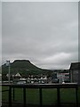
Red Bay Boats, Cushendall
The hill in the background is Lurigethan. The summit is crowned with a large promontory fort.
Image: © Eric Jones
Taken: 26 Sep 2013
0.12 miles
3
Houses on the southern outskirts of Cushendall
Image: © Eric Jones
Taken: 13 Aug 2011
0.14 miles
5
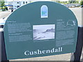
Coast and Glens information
An information board at Cushendall.
Image: © Michael Dibb
Taken: 10 Jun 2015
0.15 miles
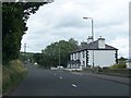
6
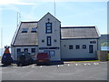
Red Bay lifeboat station
Located in Cushendall.
Image: © Michael Dibb
Taken: 10 Jun 2015
0.16 miles
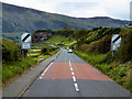
7
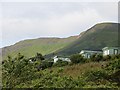
Caravan park, Red Bay
Under the crags of Lurigethan near Cushendall.
Image: © Richard Webb
Taken: 5 Aug 2013
0.17 miles
8
![Cushendall caravan park [2]](https://s2.geograph.org.uk/geophotos/04/55/65/4556514_de12f5a9_120x120.jpg)
Cushendall caravan park [2]
Another view of the caravan park illustrating the closeness of Scotland only some 16 miles distant. The caravan park does offer wonderful views.
Image: © Michael Dibb
Taken: 10 Jun 2015
0.18 miles
9
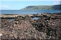
Red Bay
The foreground red rocks, from which the bay presumably takes its name, are conglomerates and sandstones of the Red Arch Foundation, laid down by flash floods on an alluvial fan. Their exact age is still the subject of debate.
Image: © Anne Burgess
Taken: 29 May 2007
0.18 miles
10
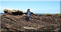
Unconformity
An unconformity is where there is a gap in time between one layer of rocks and the layer above it. Here, there is an angle between the topmost bed of rock and the beds underneath, which must have been tilted by tectonic movements after being laid down and before the topmost layer was deposited. The similarity to the classic unconformity at Siccar Point Image is easy to see. Geologist for scale.
Image: © Anne Burgess
Taken: 29 May 2007
0.18 miles