IMAGES TAKEN NEAR TO
Longmore Road, BALLYMENA, BT43 7HR
Introduction
This page details the photographs taken nearby to Longmore Road, BT43 7HR by members of the Geograph project.
The Geograph project started in 2005 with the aim of publishing, organising and preserving representative images for every square kilometre of Great Britain, Ireland and the Isle of Man.

There are currently over 7.5m images from over14,400 individuals and you can help contribute to the project by visiting https://www.geograph.org.uk
Image Map
Images are licensed for reuse under creativecommons.org/licenses/by-sa/2.0
Notes
- Clicking on the map will re-center to the selected point.
- The higher the marker number, the further away the image location is from the centre of the postcode.
Image Listing (3 Images Found)
Images are licensed for reuse under creativecommons.org/licenses/by-sa/2.0
Image
Details
Distance
1
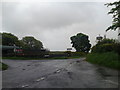
Longmore Crossroads
The Longmore Road where it meets Glens Brae Road and Tullymore Road.A farmyard and tractor is visible in the background on a wet day.
Image: © Paul L
Taken: 22 May 2009
0.03 miles
2
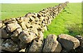
Drystone walls near Martinstown
Drystone walls are common in the Glens of Antrim. These two are beside the Glens Brae Road Image
Image: © Albert Bridge
Taken: 3 Apr 2009
0.14 miles
3
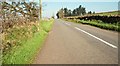
The Glens Brae Road near Martinstown
See Image and Image The Glens Brae Road (“Glen’s” on the Google map and “Glens” on the road sign and 1:25,000 OS map) is the northward continuation of both in the direction of Martinstown.
Image: © Albert Bridge
Taken: 3 Apr 2009
0.20 miles