IMAGES TAKEN NEAR TO
Burma Place, BALLYMENA, BT43 7AU
Introduction
This page details the photographs taken nearby to Burma Place, BT43 7AU by members of the Geograph project.
The Geograph project started in 2005 with the aim of publishing, organising and preserving representative images for every square kilometre of Great Britain, Ireland and the Isle of Man.

There are currently over 7.5m images from over14,400 individuals and you can help contribute to the project by visiting https://www.geograph.org.uk
Image Map
Images are licensed for reuse under creativecommons.org/licenses/by-sa/2.0
Notes
- Clicking on the map will re-center to the selected point.
- The higher the marker number, the further away the image location is from the centre of the postcode.
Image Listing (21 Images Found)
Images are licensed for reuse under creativecommons.org/licenses/by-sa/2.0
Image
Details
Distance
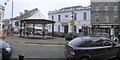
1
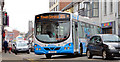
Town service bus, Ballymena (April 2014)
An Ulsterbus Wright-bodied Scania (2433 GXI 433) departing from the stop in Broughshane Street with the 10.25 Dunclurg service. This is a circular service, to/from the bus station Image, running every 30 minutes.
Image: © Albert Bridge
Taken: 4 Apr 2014
0.18 miles
2
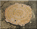
Stanton "Saracen" manhole cover, Ballymena
A Stanton and Staveley “Saracen” manhole cover at Garfield Place.
Image: © Albert Bridge
Taken: 15 Aug 2012
0.19 miles
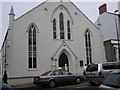
3
First Ballymena Presbyterian Church Halls
This is the oldest Presbyterian Church in the Ballymena area. It is also one of the oldest in Northern Ireland having been established by members of the Scottish Kirk who came during the Plantation of Ulster. The first Presbyterian minister to serve in the church back in 1627 was Rev George Dunbar.
Church website: https://www.firstballymena.org/
Image: © Gerald England
Taken: 13 Sep 2020
0.20 miles
4
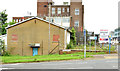
Development site, Trostan Avenue, Ballymena (June 2014)
A vacant building, at the corner of Trostan Avenue (right) and Castle Demesne Link offered for sale and described by the agents as “The subject property was formerly the Ballymena Senior Citizens Club and is located on a square shaped site extending to approximately 0.19 acres with 26m (86 ft.) of frontage onto Trostan Avenue. . . . . Planning has been passed for a proposed scheme incorporating 4 storeys of open plan Grade A office accommodation, with 15 car parking spaces in the basement totalling 15,349 sq.ft. Planning Application No. G/2009/0207/F”. This photograph appears as a matter of geographical and historical record only. I have no connection with any of the parties involved in the sale.
Image: © Albert Bridge
Taken: 13 Jun 2014
0.20 miles
5
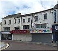
Shops on Church Street
All currently closed. Toytown has closed permanently.
Image: © Gerald England
Taken: 13 Sep 2020
0.20 miles
6
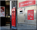
Letter box, Ballymena
EIIR wall box at the Crown office in Wellington Street.
Image: © Albert Bridge
Taken: 30 Apr 2011
0.22 miles
7
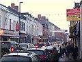
Busy day in Ballymoney Street, Ballymena
The town has gone crazy with shoppers availing of the post-Christmas sales (formerly known as the January sales - they now seem to start at 7am on Boxing Day).
Image: © Dean Molyneaux
Taken: 28 Dec 2009
0.22 miles
8
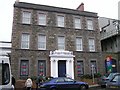
First Trust Bank, Ballymena
It is located at Wellington Street.
Image: © Kenneth Allen
Taken: 17 Feb 2007
0.22 miles
9
Ballymena Town
The building with the white façade is the Bank of Ireland.
Image: © Kenneth Allen
Taken: 17 Feb 2007
0.22 miles
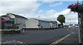
10
Wellington Street Presbyterian Church, Ballymena
Plenty of traffic about.
Image: © Kenneth Allen
Taken: 17 Feb 2007
0.22 miles