IMAGES TAKEN NEAR TO
Sydenham Avenue, BELFAST, BT4 2DU
Introduction
This page details the photographs taken nearby to Sydenham Avenue, BT4 2DU by members of the Geograph project.
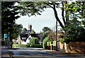
The Geograph project started in 2005 with the aim of publishing, organising and preserving representative images for every square kilometre of Great Britain, Ireland and the Isle of Man.

There are currently over 7.5m images from over14,400 individuals and you can help contribute to the project by visiting https://www.geograph.org.uk
Image Map
Images are licensed for reuse under creativecommons.org/licenses/by-sa/2.0
Notes
- Clicking on the map will re-center to the selected point.
- The higher the marker number, the further away the image location is from the centre of the postcode.
Image Listing (92 Images Found)
Images are licensed for reuse under creativecommons.org/licenses/by-sa/2.0
Image
Details
Distance
1
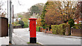
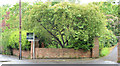
Pillar box, Belfast
EIIR pillar box at Sydenham Avenue, near Norwood Gardens.
Image: © Albert Bridge
Taken: 13 Apr 2011
0.02 miles
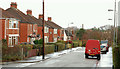
2
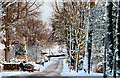
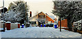
Sydenham Avenue Belfast (3)
See Image A snow-covered Sydenham Avenue looking towards the Circular Road. The footpaths were covered by snow but were not slippery. The road needed care. Continue to Image
Image: © Albert Bridge
Taken: 17 Dec 2010
0.03 miles
3
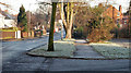
Sydenham Avenue, Belfast (2)
See Image The same part of Sydenham Avenue showing the heavy frost which has persisted over the last few days. Continue to Image
Image: © Albert Bridge
Taken: 28 Dec 2009
0.04 miles
4
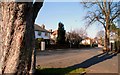
Sydenham Avenue, Belfast
Sydenham Avenue runs from the Holywood Road towards the Circular Road (just out of sight at middle right). This end is low-density detached houses. Continue to Image
Image: © Albert Bridge
Taken: 18 Feb 2008
0.04 miles
5
The Circular Road, Belfast (October 2014)
A suburban road running in a loop on the south eastern side of the Holywood Road. The 1901 street directory shows only a few houses, cottages and gate lodges at the Station Road end. Completion was after WW1. Before it was built the name “Circular Road” referred to a road off the Antrim Road - later re-named “North Circular Road” Image This view is from near “CI” Image looking towards Sydenham Avenue Image with the tower of Belmont Presbyterian church http://www.geograph.org.uk/snippet/7848 at middle left.
Image: © Albert Bridge
Taken: 7 Oct 2014
0.07 miles
6
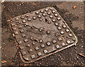
"Bells" access cover, Belfast
See Image Another access cover bearing the name “Bell & Co”. This one is on the Circular Road, close to Sydenham Avenue.
Image: © Albert Bridge
Taken: 26 Sep 2011
0.09 miles
7
Building site for sale, Sydenham, Belfast (2013)
A site, on the Circular Road, beside Orchard Lane. The agents’ board reads “For sale site approx .53 acres”. This photograph appears as a matter of record only. I have no connection with any of the parties involved in the sale.
Image: © Albert Bridge
Taken: 3 Jun 2013
0.09 miles
8
Laurelvale, Belfast
A small cul-de-sac off Sydenham Avenue – even the wheelie bins had a deep coating of snow.
Image: © Albert Bridge
Taken: 17 Dec 2010
0.11 miles
9
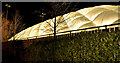
Inflatable building, Belfast (3)
See Image A similar building at the CIYMS (“CI”) sports ground off the Circular Road. The view is from Strathearn Lane (“Circular Road” on the Google map).
Image: © Albert Bridge
Taken: 14 Dec 2011
0.11 miles
10
Norwood Drive, Belfast
A street of semis running from Sydenham Avenue to the Circular Road (background). Known (I think) as “McMillan houses”.
Image: © Albert Bridge
Taken: 25 Nov 2009
0.12 miles