IMAGES TAKEN NEAR TO
Shona Green, BALLYMENA, BT42 4AT
Introduction
This page details the photographs taken nearby to Shona Green, BT42 4AT by members of the Geograph project.
The Geograph project started in 2005 with the aim of publishing, organising and preserving representative images for every square kilometre of Great Britain, Ireland and the Isle of Man.

There are currently over 7.5m images from over14,400 individuals and you can help contribute to the project by visiting https://www.geograph.org.uk
Image Map
Images are licensed for reuse under creativecommons.org/licenses/by-sa/2.0
Notes
- Clicking on the map will re-center to the selected point.
- The higher the marker number, the further away the image location is from the centre of the postcode.
Image Listing (2 Images Found)
Images are licensed for reuse under creativecommons.org/licenses/by-sa/2.0
Image
Details
Distance
1
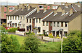
Barra Drive, Ballymena (June 2014)
Barra Drive, part of the 1960’s Ballykeel estate, seen from the side of Harryville motte Image
Image: © Albert Bridge
Taken: 13 Jun 2014
0.17 miles
2
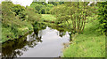
The Braid, Ballymena - June 2014(3)
The Braid, looking upstream from the Ballykeel Bridge on the dual carriageway out to the M2 Larne Road roundabout. The banks upstream are part of the undeveloped and preserved area leading to here Image and Image and to the Ecos centre Image
Image: © Albert Bridge
Taken: 13 Jun 2014
0.19 miles