IMAGES TAKEN NEAR TO
Braidwater Retail Park, Larne Road Link, BALLYMENA, BT42 3ES
Introduction
This page details the photographs taken nearby to Braidwater Retail Park, Larne Road Link, BT42 3ES by members of the Geograph project.
The Geograph project started in 2005 with the aim of publishing, organising and preserving representative images for every square kilometre of Great Britain, Ireland and the Isle of Man.

There are currently over 7.5m images from over14,400 individuals and you can help contribute to the project by visiting https://www.geograph.org.uk
Image Map
Images are licensed for reuse under creativecommons.org/licenses/by-sa/2.0
Notes
- Clicking on the map will re-center to the selected point.
- The higher the marker number, the further away the image location is from the centre of the postcode.
Image Listing (43 Images Found)
Images are licensed for reuse under creativecommons.org/licenses/by-sa/2.0
Image
Details
Distance
1
The Braid, Ballymena - June 2014(2)
The wooded banks of the Braid, looking downstream from the McNinch Bridge Image The retail park is visible at the top.
Image: © Albert Bridge
Taken: 13 Jun 2014
0.04 miles
2
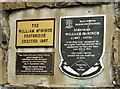
The William McNinch footbridge plaques, Ballymena
See Image Three self-explanatory plaques at the Edward Street end of the bridge.
Image: © Albert Bridge
Taken: 13 Jun 2014
0.05 miles
3
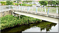
The William McNinch footbridge, Ballymena
A footbridge, across the Braid, erected to replace one built in 1957. It now connects Harryville to the Braidwater Retail Park. Edward Street is behind me. The original bridge (before this part of Ballymena was developed) should be visible in this Facebook link https://www.facebook.com/Oldphotosballymena/photos/a.396081643848007.1073741837.254410138015159/313962352059937/?type=1. Image provides more information.
Image: © Albert Bridge
Taken: 13 Jun 2014
0.06 miles
5
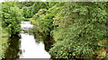
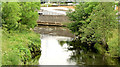
The Braid, Ballymena - June 2014(1)
The wooded banks of the Braid, looking upstream from the McNinch Bridge Image The dual carriageway and the Braidwater Retail Park are hidden, out of picture to the left.
Image: © Albert Bridge
Taken: 13 Jun 2014
0.08 miles
6
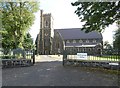
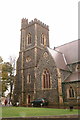
St Patrick's Church of Ireland
Ballymena Parish Church was consecrated in 1855. It was totally destroyed by a fire in 1879 but rebuilt along the same lines and re-opened in 1881. It is famed for having the only peel of twelve bells in Northern Ireland. For more details see the church website: http://www.stpatricksballymena.co.uk/
Image: © Gerald England
Taken: 13 Sep 2020
0.11 miles
7
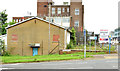
Development site, Trostan Avenue, Ballymena (June 2014)
A vacant building, at the corner of Trostan Avenue (right) and Castle Demesne Link offered for sale and described by the agents as “The subject property was formerly the Ballymena Senior Citizens Club and is located on a square shaped site extending to approximately 0.19 acres with 26m (86 ft.) of frontage onto Trostan Avenue. . . . . Planning has been passed for a proposed scheme incorporating 4 storeys of open plan Grade A office accommodation, with 15 car parking spaces in the basement totalling 15,349 sq.ft. Planning Application No. G/2009/0207/F”. This photograph appears as a matter of geographical and historical record only. I have no connection with any of the parties involved in the sale.
Image: © Albert Bridge
Taken: 13 Jun 2014
0.14 miles
8
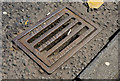
Kanes grating cover, Ballymena
A grating cover, at Henry Street (Larne Street on the Google map), with the inscription “Kane Brothers Iron Founders Ballymena”. For two other covers from the same foundry, to a different design, see Image and Image
Image: © Albert Bridge
Taken: 17 May 2013
0.14 miles
9
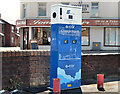
E-car charge point, Ballymena
An E-car charging point at the Henry Street (Larne Street on the Google map)/Gilmore Street car park.
Image: © Albert Bridge
Taken: 17 May 2013
0.15 miles