IMAGES TAKEN NEAR TO
Grove Park, BALLYMENA, BT42 3EN
Introduction
This page details the photographs taken nearby to Grove Park, BT42 3EN by members of the Geograph project.
The Geograph project started in 2005 with the aim of publishing, organising and preserving representative images for every square kilometre of Great Britain, Ireland and the Isle of Man.

There are currently over 7.5m images from over14,400 individuals and you can help contribute to the project by visiting https://www.geograph.org.uk
Image Map
Images are licensed for reuse under creativecommons.org/licenses/by-sa/2.0
Notes
- Clicking on the map will re-center to the selected point.
- The higher the marker number, the further away the image location is from the centre of the postcode.
Image Listing (3 Images Found)
Images are licensed for reuse under creativecommons.org/licenses/by-sa/2.0
Image
Details
Distance
1
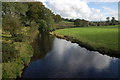
Glenwhirry River (view upstream)
The Glenwhirry River rises near Ballyboley Forest and flows into the Kellswater to the east of Ballymena. This is the river (looking upstream) as seen from the Battery Bridge.
Image: © Albert Bridge
Taken: 10 Oct 2006
0.07 miles
2
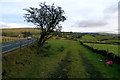
Disused road
At one time the Ballymena to Larne Road must have followed this straight line and the section still in use for local access can be seen in the distance. For some reason it appears to have been diverted to the left to curve round in a loop and rejoin the original line at the far end. Most roads are realigned to remove bends but this one has had a straight section cut off and a bend inserted. On the satellite image the original line can be seen meeting the still existing eastern section halfway. Maybe someone with a knowledge of local history can throw some light on this apparent anomaly.
Image: © Robert Ashby
Taken: 7 Feb 2015
0.13 miles
3
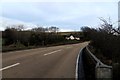
On the A36
Approaching Lynn's Bridge near Glenwherry travelling towards Larne. This is on the bend on the realigned section. See photo 4343877.
Image: © Robert Ashby
Taken: 7 Feb 2015
0.20 miles