IMAGES TAKEN NEAR TO
Larne Road, BALLYMENA, BT42 3AX
Introduction
This page details the photographs taken nearby to Larne Road, BT42 3AX by members of the Geograph project.
The Geograph project started in 2005 with the aim of publishing, organising and preserving representative images for every square kilometre of Great Britain, Ireland and the Isle of Man.

There are currently over 7.5m images from over14,400 individuals and you can help contribute to the project by visiting https://www.geograph.org.uk
Image Map
Images are licensed for reuse under creativecommons.org/licenses/by-sa/2.0
Notes
- Clicking on the map will re-center to the selected point.
- The higher the marker number, the further away the image location is from the centre of the postcode.
Image Listing (15 Images Found)
Images are licensed for reuse under creativecommons.org/licenses/by-sa/2.0
Image
Details
Distance
1
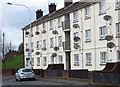
Anything good on telly?
An apartment block festooned with satellite dishes on Larne Road, Ballymena.
Image: © Robert Ashby
Taken: 7 Apr 2016
0.01 miles
2
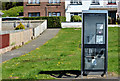
Telephone box, Harryville, Ballymena
Telephone box, at Chichester Park East, on the Larne Road.
Image: © Albert Bridge
Taken: 17 May 2013
0.04 miles
3
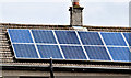
Solar panels, Ballymena (July 2014)
Domestic solar panels, at Harryville, seen from the Larne Road.
Image: © Albert Bridge
Taken: 3 Jul 2014
0.07 miles
4
Harryville gospel hall, Ballymena
A gospel hall on the Larne Road, built (I think but I might be wrong) in the early 1970’s.
Image: © Albert Bridge
Taken: 17 May 2013
0.11 miles
5
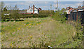
Former St Mary's School site, Ballymena (July 2014)
See Image (May 2013). There is now a “sold” patch on the agents’ sign at this potential development site, on the Larne Road.
Image: © Albert Bridge
Taken: 3 Jul 2014
0.11 miles
6
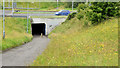
Subway, Ballykeel, Ballymena
A subway, under the dual carriageway Larne Road Link, leading from the Ballykeel estate (behind me). The Larne Road Link joins the town to the Larne Road roundabout and the bypass.
Image: © Albert Bridge
Taken: 3 Jul 2014
0.13 miles
7
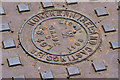
Northern Ireland Castings access cover, Ballymena (July 2014)
The inscription on a Northern Ireland Castings access cover (similar to this one Image) on the Larne Road Link, on the town side of the Ballykeel roundabout.
Image: © Albert Bridge
Taken: 3 Jul 2014
0.13 miles
8
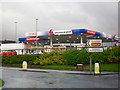
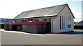
Tesco Filling Station, Ballymena
At the Larne Road Tesco complex - seen here at the Crebilly Road/Larne Road roundabout.
Image: © Dean Molyneaux
Taken: 23 Aug 2009
0.17 miles
9
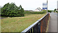
Potential development site, Harryville, Ballymena
A very small part of a cleared site, fronting the Larne Road, offered for sale as a “potential development site” and described by the agent as a “Site at Larne Road Ballymena formally [sic] St Mary's Primary School. Site circa 4.57 acres with access from Larne Road available for mixed use subject to necessary planning permission”. This photograph appears as a matter of record only. I have no connection with any of the parties involved in the sale. Continue to Image
Image: © Albert Bridge
Taken: 17 May 2013
0.18 miles
10
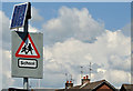
Solar panel, Ballymena
A solar panel powering the flashing lights on a “school” sign, on the Larne Road, close to here Image
Image: © Albert Bridge
Taken: 17 May 2013
0.19 miles