IMAGES TAKEN NEAR TO
Slaght Road, BALLYMENA, BT42 2JH
Introduction
This page details the photographs taken nearby to Slaght Road, BT42 2JH by members of the Geograph project.
The Geograph project started in 2005 with the aim of publishing, organising and preserving representative images for every square kilometre of Great Britain, Ireland and the Isle of Man.

There are currently over 7.5m images from over14,400 individuals and you can help contribute to the project by visiting https://www.geograph.org.uk
Image Map
Images are licensed for reuse under creativecommons.org/licenses/by-sa/2.0
Notes
- Clicking on the map will re-center to the selected point.
- The higher the marker number, the further away the image location is from the centre of the postcode.
Image Listing (3 Images Found)
Images are licensed for reuse under creativecommons.org/licenses/by-sa/2.0
Image
Details
Distance
1
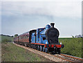
171 at Slaght
Former GNR(I) 4.4.0 No. 171 "Slieve Gullion" brings the RPSI "Belfast & Northern Counties" railtour towards Slaght crossing, south of Ballymena.
Image: © The Carlisle Kid
Taken: 13 May 2001
0.09 miles
2
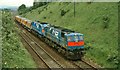
Diesel superpower near Ballymena
Almost 4,500 bhp is on tap to handle seven loaded ballast hoppers. Not the waste it seems though. The train was intended to assist in the monitoring of vibration levels at the site of the (then) proposed science park, beside the railway, to the south of Antrim. It is approaching Slaght Bridge.
Image: © Albert Bridge
Taken: 7 Jul 1985
0.10 miles