
IMAGES TAKEN NEAR TO
Windrush Manor, ANTRIM, BT41 4FJ
Introduction
This page details the photographs taken nearby to Windrush Manor, BT41 4FJ by members of the Geograph project.
The Geograph project started in 2005 with the aim of publishing, organising and preserving representative images for every square kilometre of Great Britain, Ireland and the Isle of Man.

There are currently over 7.5m images from over14,400 individuals and you can help contribute to the project by visiting https://www.geograph.org.uk
Image Map
Images are licensed for reuse under creativecommons.org/licenses/by-sa/2.0
Notes
- Clicking on the map will re-center to the selected point.
- The higher the marker number, the further away the image location is from the centre of the postcode.
Image Listing (52 Images Found)
Images are licensed for reuse under creativecommons.org/licenses/by-sa/2.0
Image
Details
Distance
1
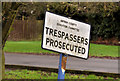
Old "trespass" sign, Antrim
An old local government “trespass” sign in the grounds of a school on the Station Road. Education was transferred to education and library boards (later just education boards) on re-organisation of local government in 1973.
Image: © Albert Bridge
Taken: 27 Dec 2011
0.07 miles
2
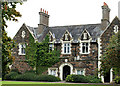
Former Masserene Hospital, Antrim
Built as a workhouse and later part of the Masserene Hospital, on the Station Road, the building has a datestone showing 1842. The hospital closed when the new Antrim Area Hospital Image opened.
Image: © Albert Bridge
Taken: 25 Sep 2010
0.09 miles
3
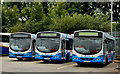
Buses, Antrim
Three of the buses based at Antrim, seen in the depot beside the bus and railway stations. All have bodies made locally by Wrights in Ballymena.
Image: © Albert Bridge
Taken: 25 Sep 2010
0.12 miles
4
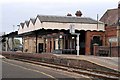
Antrim Station
The main station buildings on Platform 1,
Image: © Wilson Adams
Taken: 21 Oct 2007
0.13 miles
5
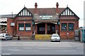
Antrim Station
A 2007 view of Antrim Station on a quiet Sunday morning
Image: © Wilson Adams
Taken: 21 Oct 2007
0.13 miles
6
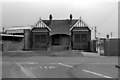
Antrim Station
A 1979 view of Antrim Station. The gateway on the right of the photo, leads to the Ulsterbus depot. Previously, this area contained an engine shed, water tower and a small goods yard belonging to the Great Northern Railway of Ireland. I'm not certain, but I think the righthand side of Antrim Station building was rented to the GNRI as a ticket office, to sell tickets to those passengers that wished to travel to Belfast via Crumlin and Lisburn.
Image: © Wilson Adams
Taken: Unknown
0.14 miles
7
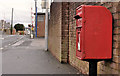
Letter box, Antrim
Post-mounted EIIR letter box close to Antrim station. The level crossing Image is in the background.
Image: © Albert Bridge
Taken: 27 Dec 2011
0.14 miles
8
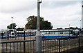
Buses at Antrim Ulsterbus Station
This image was taken from Antrim's Railway Station.
Image: © Eric Jones
Taken: 23 Sep 2013
0.14 miles
9
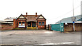
Antrim station (1)
The present Antrim railway station (built in 1901) includes a bus station (hidden between the station and the gates). Translink plans major works, starting in 2012, to incorporate the two in a modernised building retaining the station (listed as HB20/09/016). The following is an extract from a long Translink press release:
“This will be a modern, attractive and accessible transport hub fit for today’s busy lifestyle. Local people can not only expect a first class integrated bus and rail centre meeting their travel requirements but one that will also involve the sensitive restoration of the listed building’s façade. . . . . . Building on this achievement, our plans for the new Antrim facility raise the bar in terms of sustainable station development with features that will ensure its environmental impact is carefully controlled and that it operates as efficiently as possible.“ The bus depot Image is behind the wall.
Continue to Image
Image: © Albert Bridge
Taken: 27 Dec 2011
0.14 miles
10
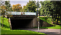
Flyover, Antrim
The flyover carrying the Castle Way (part of the through pass road) across the access to the Castle Mall shopping centre car park.
Image: © Albert Bridge
Taken: 25 Sep 2010
0.14 miles