Antrim station (1)
Introduction
The photograph on this page of Antrim station (1) by Albert Bridge as part of the Geograph project.
The Geograph project started in 2005 with the aim of publishing, organising and preserving representative images for every square kilometre of Great Britain, Ireland and the Isle of Man.

There are currently over 7.5m images from over 14,400 individuals and you can help contribute to the project by visiting https://www.geograph.org.uk
Antrim station (1)
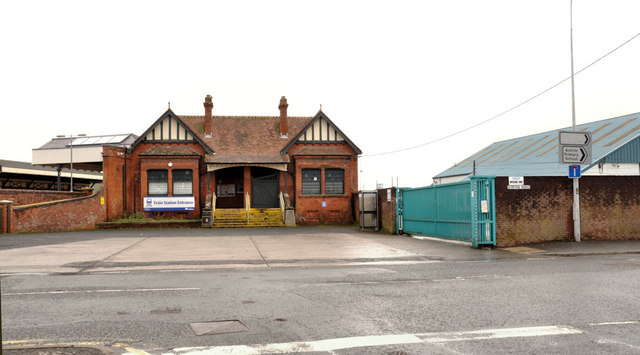
Image: © Albert Bridge Taken: 27 Dec 2011
The present Antrim railway station (built in 1901) includes a bus station (hidden between the station and the gates). Translink plans major works, starting in 2012, to incorporate the two in a modernised building retaining the station (listed as HB20/09/016). The following is an extract from a long Translink press release: “This will be a modern, attractive and accessible transport hub fit for today’s busy lifestyle. Local people can not only expect a first class integrated bus and rail centre meeting their travel requirements but one that will also involve the sensitive restoration of the listed building’s façade. . . . . . Building on this achievement, our plans for the new Antrim facility raise the bar in terms of sustainable station development with features that will ensure its environmental impact is carefully controlled and that it operates as efficiently as possible.“ The bus depot Image is behind the wall. Continue to Image
Images are licensed for reuse under creativecommons.org/licenses/by-sa/2.0
Image Location
Latitude
54.718254
Longitude
-6.211969