IMAGES TAKEN NEAR TO
Dublin Road, ANTRIM, BT41 4ED
Introduction
This page details the photographs taken nearby to Dublin Road, BT41 4ED by members of the Geograph project.
The Geograph project started in 2005 with the aim of publishing, organising and preserving representative images for every square kilometre of Great Britain, Ireland and the Isle of Man.

There are currently over 7.5m images from over14,400 individuals and you can help contribute to the project by visiting https://www.geograph.org.uk
Image Map
Images are licensed for reuse under creativecommons.org/licenses/by-sa/2.0
Notes
- Clicking on the map will re-center to the selected point.
- The higher the marker number, the further away the image location is from the centre of the postcode.
Image Listing (14 Images Found)
Images are licensed for reuse under creativecommons.org/licenses/by-sa/2.0
Image
Details
Distance
1
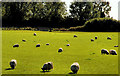
Field near Antrim (1)
A field, to the east of Rea’s Wood Image, which (I think) is part of Greenmount College.
Image: © Albert Bridge
Taken: 4 Oct 2010
0.07 miles
2
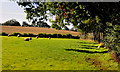
Field near Antrim (2)
Image: © Albert Bridge
Taken: 4 Oct 2010
0.10 miles
3
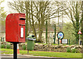
Postbox BT41 16, Antrim
Post-mounted EIIR box (BT41 16) at Woodland Grove on the Dublin Road.
Image: © Albert Bridge
Taken: 21 Apr 2014
0.11 miles
4
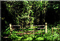
Gate, Rea's Wood, Antrim (1)
About half-way through the wood this gate marks the point where the path diverges. Behind me to the left it continues, through the wood towards the loughshore. To the right a path leads to the Dublin Road.
Image: © Albert Bridge
Taken: 4 Oct 2010
0.19 miles
5
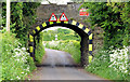
Kirby's Lane, Antrim
The railway bridge on the now closed Antrim to Lisburn line where it crosses over Kirby's Lane
Image: © Robert Ashby
Taken: 23 May 2004
0.21 miles
6
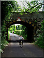
Railway bridge near Antrim (2013-1)
The eastern side of a single-arch stone bridge (last seen in Image (May 2004)) carrying the mothballed Lisburn (left) – Antrim railway across Kirby’s Lane. Kirby’s Lane is a narrow minor road running to the north of Greenmount College Image, from the Tirgracey Road to the Dublin Road. Continue to Image
Image: © Albert Bridge
Taken: 1 Jun 2013
0.21 miles
7
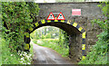
Railway bridge near Antrim (2013-2)
Image: © Albert Bridge
Taken: 1 Jun 2013
0.21 miles
8
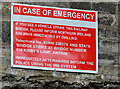
Railway bridge near Antrim (2013-3)
See Image The bridge-strike sign on the western side. It’s attached to a raised parapet, made from concrete blocks, added (to the best of my knowledge) during the renewal work in 1973/74.
Image: © Albert Bridge
Taken: 1 Jun 2013
0.21 miles
9
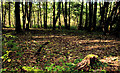
Rea's Wood, Antrim (6)
Image: © Albert Bridge
Taken: 4 Oct 2010
0.22 miles
10
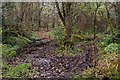
Rea's Wood, Antrim (3)
See Image A soggy section of the path through the wood. It divides slightly further south with a “branch” continuing into J1385.
Image: © Albert Bridge
Taken: 18 Nov 2007
0.22 miles