IMAGES TAKEN NEAR TO
Drumahoe Road, LARNE, BT40 2PF
Introduction
This page details the photographs taken nearby to Drumahoe Road, BT40 2PF by members of the Geograph project.
The Geograph project started in 2005 with the aim of publishing, organising and preserving representative images for every square kilometre of Great Britain, Ireland and the Isle of Man.

There are currently over 7.5m images from over14,400 individuals and you can help contribute to the project by visiting https://www.geograph.org.uk
Image Map
Images are licensed for reuse under creativecommons.org/licenses/by-sa/2.0
Notes
- Clicking on the map will re-center to the selected point.
- The higher the marker number, the further away the image location is from the centre of the postcode.
Image Listing (5 Images Found)
Images are licensed for reuse under creativecommons.org/licenses/by-sa/2.0
Image
Details
Distance
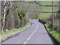
1
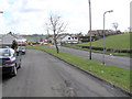
Millbrook, Larne
The road is leading to the town
Image: © Kenneth Allen
Taken: 8 Apr 2006
0.07 miles
2
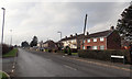
Old Belfast Road
Older housing at the Millbrook end of the Old Belfast Road which probably mostly pre-dates the dual carriageway
Image: © Robert Ashby
Taken: 13 Feb 2017
0.14 miles
3
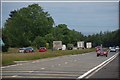
The Larne line near Larne
See Image This is the view towards Larne as the road approaches Millbrook roundabout – the fourth roundabout from the harbour.
Image: © Albert Bridge
Taken: 25 Jun 2007
0.15 miles
4
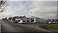
Old Belfast Road
Car dealership near Millbrook.
Image: © Robert Ashby
Taken: 13 Feb 2017
0.16 miles
5
Owen's Bridge, Larne
Heading away from the town
Image: © Kenneth Allen
Taken: 8 Apr 2006
0.25 miles