1
Holywood Exchange retail park
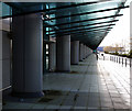
Frontage of the 150,000 square foot 'Holywood Exchange' retail complex near Belfast.
This is a view along front of the complex and, despite construction being completed many years ago (I think as long as 2002), there are few tenants here. Part of the complex (in the far distance) is occupied by 'Next Home' and 'Harvey Norman' retail outlets; the reason for the empty units lies in a long planning dispute which resulted in significant restrictions being placed on the entire development. As it stands the units are "the subject of strict guidelines that dictate that only bulky goods can be sold".
Image: © Rossographer
Taken: 23 Jan 2010
0.04 miles
2
2,3, GO!
Frontage of the 150,000 ft2 'Holywood Exchange' retail complex near Belfast.
This is a view along the northern side of the complex and, despite construction being completed many years ago (I think as long as 2002), there are no tenants here. The southern side (behind me) is partially occupied by 'Next Home' and 'Harvey Norman' retail outlets; the reason for the empty units lies in a long planning dispute which resulted in significant restrictions being placed on the entire development. As it stands the units are "the subject of strict guidelines that dictate that only bulky goods can be sold". Empty, and in an area relatively free of traffic, it makes for a good playground for bored children.....
Image: © Rossographer
Taken: 23 Jan 2010
0.10 miles
3
The Belfast Road, Holywood Exchange - June 2018(2)
The view, towards Belfast, from the flyover. The map uses the name “Holywood by-pass” although “Maryfield” has the address of 100 Belfast Road, Holywood. The lane markings (bottom) refer to Tillysburn (Knocknagoney)
Image
Image: © Albert Bridge
Taken: 25 Jun 2018
0.13 miles
4
Slip-road, Holywood Exchange flyover (4)
The off-slip from the Belfast direction.
Image: © Albert Bridge
Taken: 19 Jul 2011
0.14 miles
5
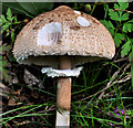
Fungus near Holywood
A fungus, which might be the parasol mushroom, growing in the grass beside the main road, near the Holywood Exchange flyover.
Image: © Albert Bridge
Taken: 19 Jul 2011
0.14 miles
6
Wildlife reserve, Tillysburn, Belfast (March 2014)
Little known and not well frequented, the Tillysburn wildlife reserve lies between the Bangor Road and the railway
Image (just above the middle). Much of it is fairly thick vegetation on both sides of a dampish path. The blue area, towards the bottom, is part of the harbour lagoons
Image and
Image
Image: © Albert Bridge
Taken: 10 Mar 2014
0.14 miles
7
'IKEA', Belfast
Swedish über retailer IKEA at Holywood Exchange on the outskirts of Belfast.
Image: © Rossographer
Taken: 19 Apr 2009
0.16 miles
8
Airport Road West near Belfast
Airport Road West runs through the eastern edge of the Belfast harbour estate and on to the Holywood Exchange retail park where it meets the A2 near Holywood. This section is approaching the end and is, in effect, a cul-de-sac built solely to serve the 'IKEA' store there.
The picture is taken from the roof of the 'IKEA' car park and you can see part of the runway of George Best Belfast City Airport to the left, from where the road derives its name.
Image: © Rossographer
Taken: 19 Apr 2009
0.16 miles
9
Direction sign, Knocknagoney, Belfast
Direction sign, approaching
Image and
Image, from the Bangor side.
Image: © Albert Bridge
Taken: 19 Jul 2011
0.16 miles
10
Snowdrops, Tillysburn, Belfast
Snowdrops and a few daffodils growing in the woodland between the railway and the Bangor Road.
Image: © Albert Bridge
Taken: 10 Mar 2014
0.17 miles


