IMAGES TAKEN NEAR TO
BELFAST, BT3 9DZ
Introduction
This page details the photographs taken nearby to BT3 9DZ by members of the Geograph project.
The Geograph project started in 2005 with the aim of publishing, organising and preserving representative images for every square kilometre of Great Britain, Ireland and the Isle of Man.

There are currently over 7.5m images from over14,400 individuals and you can help contribute to the project by visiting https://www.geograph.org.uk
Image Map
Images are licensed for reuse under creativecommons.org/licenses/by-sa/2.0
Notes
- Clicking on the map will re-center to the selected point.
- The higher the marker number, the further away the image location is from the centre of the postcode.
Image Listing (211 Images Found)
Images are licensed for reuse under creativecommons.org/licenses/by-sa/2.0
Image
Details
Distance
1
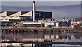
Bombardier factory, Belfast
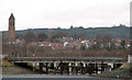
See Image The other side of the same factory, seen from the footbridge Image at Sydenham station. Now substantially modernised it was built, to a design by Hobart & Heron, between 1930 and 1950 for Short & Harland – a joint venture between Harland & Wolff and Shorts Brothers (Rochester). Part of the harbour lagoon Image is in the foreground. See also Image
Image: © Albert Bridge
Taken: 5 Nov 2011
0.04 miles
2
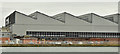
Bombardier factory, Belfast - March 2016(1)
See Image (June 2008) and Image (November 2011). Part of the Bombardier factory, on the north western side of the company’s site, seen from beside the Musgrave Channel Road.
Image: © Albert Bridge
Taken: 1 Mar 2016
0.06 miles
3
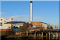
Chimney, Belfast Harbour Estate
The chimney at the Bombardier factory Image seen from the embankment Image, on the northern side of Victoria Park. This bridge Image is on the right. The cranes (middle right) at the Ship Repair Quay Image Today was bitterly cold, in exposed places (such as here) but the light was of exceptional clarity. Most of this scene is also visible (background) in Image
Image: © Albert Bridge
Taken: 3 Dec 2012
0.07 miles
4
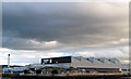
Bombardier Shorts Aerospace, Belfast
The Bombardier Shorts Aerospace factory at Airport Road, Belfast, as seen from across the Musgrave Channel.
Image: © Rossographer
Taken: 4 Mar 2008
0.07 miles
5
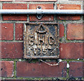
BHC Marker, Belfast
Belfast Harbour Commission marker located on the Bombardier factory on Airport Road in Belfast Image The number on this one is 57. See also http://www.geograph.org.uk/search.php?i=16953880 for related images.
Image: © Rossographer
Taken: 2 Apr 2012
0.08 miles
6
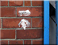
Bench Mark, Belfast
Cut bench mark on the corner of the Bombardier factory on Airport Road in Belfast Image
The mark is 4.14 metres above MSL.
Image: © Rossographer
Taken: 2 Apr 2012
0.08 miles
7
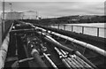
Pipes, Belfast
Pipework at the Spirit Aerosystems Belfast factory on Airport Road.
Image: © Rossographer
Taken: 4 Feb 2023
0.08 miles
8
Pipes, Belfast
Pipework running over a bridge at Airport Road in Belfast.
Image: © Rossographer
Taken: 4 Feb 2023
0.10 miles
9
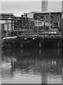
Bridge, Musgrave Channel Belfast
This is a bridge that leads from Airport Road into the Bombardier Shorts Aerospace factory in Belfast. The stretch of water that it crosses would appear to mark the mouth of Conn's Water as it leaves the area around Victoria Park and meets Belfast Lough in the Musgrave Channel.
Image: © Rossographer
Taken: 4 Mar 2008
0.10 miles
10
Airport Road, Belfast
Road running through the eastern part of the Belfast Harbour Estate. The road was probably first laid out c1920 and is marked on maps from that time as the Connswater Road; it was probably renamed later when it ran to the new aerodrome (opened 1933) which was formed on the reclaimed land at Sydenham. This aerodrome is now George Best Belfast City Airport http://www.geograph.org.uk/search.php?i=30014158 and is mainly accessed from the Sydenham bypass, although there is (non-public) access from Airport Road. The Bombardier factory is on the left, this first opened in 1936 Image The BHC marker on the wall can be seen at Image
Image: © Rossographer
Taken: 2 Apr 2012
0.10 miles