IMAGES TAKEN NEAR TO
Sydenham Road, BELFAST, BT3 9DR
Introduction
This page details the photographs taken nearby to Sydenham Road, BT3 9DR by members of the Geograph project.
The Geograph project started in 2005 with the aim of publishing, organising and preserving representative images for every square kilometre of Great Britain, Ireland and the Isle of Man.

There are currently over 7.5m images from over14,400 individuals and you can help contribute to the project by visiting https://www.geograph.org.uk
Image Map
Images are licensed for reuse under creativecommons.org/licenses/by-sa/2.0
Notes
- Clicking on the map will re-center to the selected point.
- The higher the marker number, the further away the image location is from the centre of the postcode.
Image Listing (338 Images Found)
Images are licensed for reuse under creativecommons.org/licenses/by-sa/2.0
Image
Details
Distance
1
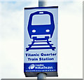
Titanic Quarter railway station sign, Belfast (November 2014)
A sign, on the Sydenham Road, at the entrance to The Titanic Quarter station via this footbridge Image Anyone intending to make the journey should allow 15 minutes between the station and the Queen’s Road.
Image: © Albert Bridge
Taken: 1 Nov 2014
0.01 miles
2
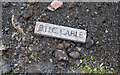
B.H.C. brick, Belfast
A brick marked "B.H.C. Cable" uncovered alongside the Sydenham Road, Belfast. It is one of many, uncovered by the civil engineering works in the area as seen in Image I imagine it covered a Belfast Harbour Commission electricity cable - similar to these found widely Image
Image: © Rossographer
Taken: 10 Nov 2021
0.01 miles
3
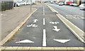
Cycle lanes, Sydenham Road, Belfast (January 2015)
See Image The corresponding cycle lanes, with “keep left” markings, looking towards the Dee Street roundabout Image
Image: © Albert Bridge
Taken: 19 Jan 2015
0.01 miles
4
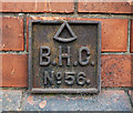
BHC Marker, Belfast
Belfast Harbour Commission marker located on the old shipyard wall running along the Sydenham Road in Belfast Image The number on this one is 56. See also http://www.geograph.org.uk/search.php?i=16953880 for related images.
Image: © Rossographer
Taken: 2 Apr 2012
0.01 miles
5
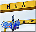
National Cycle Network signs, Belfast (January 2015)
National Cycle Network direction signs (route 99), on the Sydenham Road, opposite the path to Titanic Quarter station http://www.geograph.org.uk/snippet/6688. The Harland & Wolff cranes “Samson” and “Goliath” are in the background. See also Image
Image: © Albert Bridge
Taken: 19 Jan 2015
0.01 miles
6
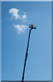
Cherry picker, Belfast
Man in a cherry picker on Sydenham Road in Belfast releasing a new cloud.
Image: © Rossographer
Taken: 5 Jun 2023
0.02 miles
7
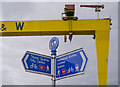
National Cycle Network sign, Belfast
Sign, for route 99, on Sydenham Road beneath the towering 'Goliath' crane.
Image: © Rossographer
Taken: 18 Aug 2014
0.02 miles
8
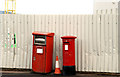
Two letter boxes, Belfast
Two boxes on the Sydenham Road. The one on the left is for franked mail. The other is a standard EIIR pillar box.
Image: © Albert Bridge
Taken: 26 Jan 2011
0.02 miles
9
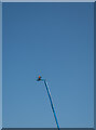
Cherry picker, Belfast
Man in a cherry picker on Sydenham Road in Belfast checking the daily cloud status.
Image: © Rossographer
Taken: 5 Jun 2023
0.03 miles
10
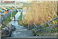
Path, Titanic Quarter station, Belfast - December 2017(1)
The path and steps, from the Titanic Quarter station footbridge Image, to the Sydenham Road and Titanic Quarter. They do not appear to be included in the proposed environmental improvements (see the shared description below).
Image: © Albert Bridge
Taken: 28 Dec 2017
0.03 miles