IMAGES TAKEN NEAR TO
Antrim Road, BALLYCLARE, BT39 0AJ
Introduction
This page details the photographs taken nearby to Antrim Road, BT39 0AJ by members of the Geograph project.
The Geograph project started in 2005 with the aim of publishing, organising and preserving representative images for every square kilometre of Great Britain, Ireland and the Isle of Man.

There are currently over 7.5m images from over14,400 individuals and you can help contribute to the project by visiting https://www.geograph.org.uk
Image Map
Images are licensed for reuse under creativecommons.org/licenses/by-sa/2.0
Notes
- Clicking on the map will re-center to the selected point.
- The higher the marker number, the further away the image location is from the centre of the postcode.
Image Listing (19 Images Found)
Images are licensed for reuse under creativecommons.org/licenses/by-sa/2.0
Image
Details
Distance
1
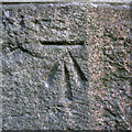
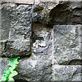
Bench Mark, Templepatrick
Cut bench mark located on a railway bridge on the outskirts of Templepatrick Image This mark was created in the mid 1970's when it was discovered that a flush bracket on the bridge had been removed - see Image
The mark has been levelled to 59.51 metres above MSL.
See also http://www.geograph.org.uk/search.php?i=11037856 for many other examples I have found.
Image: © Rossographer
Taken: 19 May 2011
0.02 miles
2
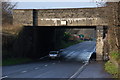
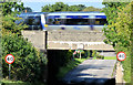
Railway bridge near Templepatrick
This bridge carries the Belfast-Londonderry railway across the Belfast – Templepatrick/Antrim road (known as “the Antrim line”). It allows ample clearance for double-deck buses (which have recently been re-introduced to the route) to pass under. The view is towards Templepatrick.
Image: © Albert Bridge
Taken: 11 Jan 2007
0.03 miles
3
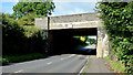
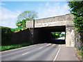
Railway bridge, Belfast road, Templepatrick - August 2014(1)
The bridge, from the Belfast/Glengormley side, looking towards Templepatrick. The stonework is original. The rest is a result of rebuilding.
Image: © Albert Bridge
Taken: 11 Aug 2014
0.03 miles
4
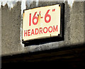
Railway bridge, Belfast road, Templepatrick - August 2014(2)
The surviving height-restriction sign (UTA era, I think) on the Belfast/Glengormley side.
Image: © Albert Bridge
Taken: 11 Aug 2014
0.03 miles
5
Railway bridge, Belfast road, Templepatrick - August 2014(3)
The 10.10 Belfast Gt Victoria Street – Portrush crossing the Belfast road bridge (from right to left).
Image: © Albert Bridge
Taken: 11 Aug 2014
0.03 miles
6
Railway bridge, Templepatrick
Railway bridge over the A6 Antrim road on the outskirts of Templepatrick. The bridge carries the line between Belfast and L'Derry over the road.
Image: © Rossographer
Taken: 19 May 2011
0.05 miles
7
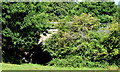
(Former) Flush Bracket, Templepatrick
The site of a flush bracket bench mark which used to be sited at a railway bridge on the outskirts of Templepatrick Image The bracket was removed sometime in the early 1970s. A cut mark was subsequently added to the bridge when it was discovered that the bracket had gone Image Should you have the bracket, maybe you could drop me a line? Perhaps it lies dusty and forgotten in your garden shed or have you given it pride of place on your mantlepiece?
When it was here, the bracket was numbered OSBM 3266.
The mark was levelled to 59.01 metres above MSL.
A flush bracket is a type of bench mark set onto the face of a building. See also http://www.geograph.org.uk/search.php?i=11037856 for many other examples I have found.
Image: © Rossographer
Taken: 19 May 2011
0.05 miles
8
Railway underbridge, Templepatrick (August 2014)
An underbridge (no public access) a short distance on the Belfast side of the Belfast road bridge http://www.geograph.org.uk/snippet/11643. It was rebuilt as part of the works for the re-opening of the line in 2001.
Image: © Albert Bridge
Taken: 11 Aug 2014
0.06 miles
9
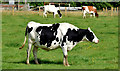
Cattle, Templepatrick - August 2014(1)
In a field beside the Belfast road.
Image: © Albert Bridge
Taken: 11 Aug 2014
0.08 miles
10
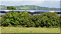
Railway embankment, Templepatrick (August 2014)
A low railway embankment on the Belfast side of this bridge Image Belfast is to the right. The train is the 10.10 Belfast Gt Victoria Street – Portrush.
Image: © Albert Bridge
Taken: 11 Aug 2014
0.09 miles